You are here: Home > Network List > TA - USArray Transportable Network (new EarthScope stations) Stations List
> Station D07A Quincy, WA, USA > Earthquake Result Viewer
D07A Quincy, WA, USA - Earthquake Result Viewer
| Earthquake location: |
Solomon Islands |
| Earthquake latitude/longitude: |
-8.5/157.0 |
| Earthquake time(UTC): |
2007/04/01 (091) 20:39:56 GMT |
| Earthquake Depth: |
10 km |
| Earthquake Magnitude: |
6.8 MB, 7.9 MS, 8.1 MW, 7.7 ME |
| Earthquake Catalog/Contributor: |
WHDF/NEIC |
|
| Network: |
TA USArray Transportable Network (new EarthScope stations) |
| Station: |
D07A Quincy, WA, USA |
| Lat/Lon: |
47.19 N/119.97 W |
| Elevation: |
453 m |
|
| Distance: |
91.4 deg |
| Az: |
42.615 deg |
| Baz: |
259.157 deg |
| Ray Param: |
0.041604593 |
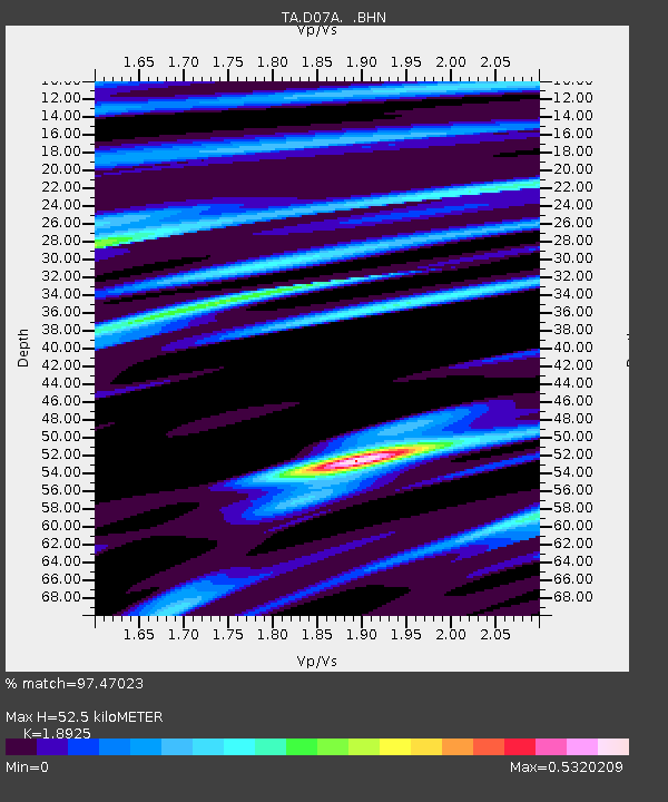
| Estimated Moho Depth: |
52.5 km |
| Estimated Crust Vp/Vs: |
1.89 |
| Assumed Crust Vp: |
6.419 km/s |
| Estimated Crust Vs: |
3.392 km/s |
| Estimated Crust Poisson's Ratio: |
0.31 |
|
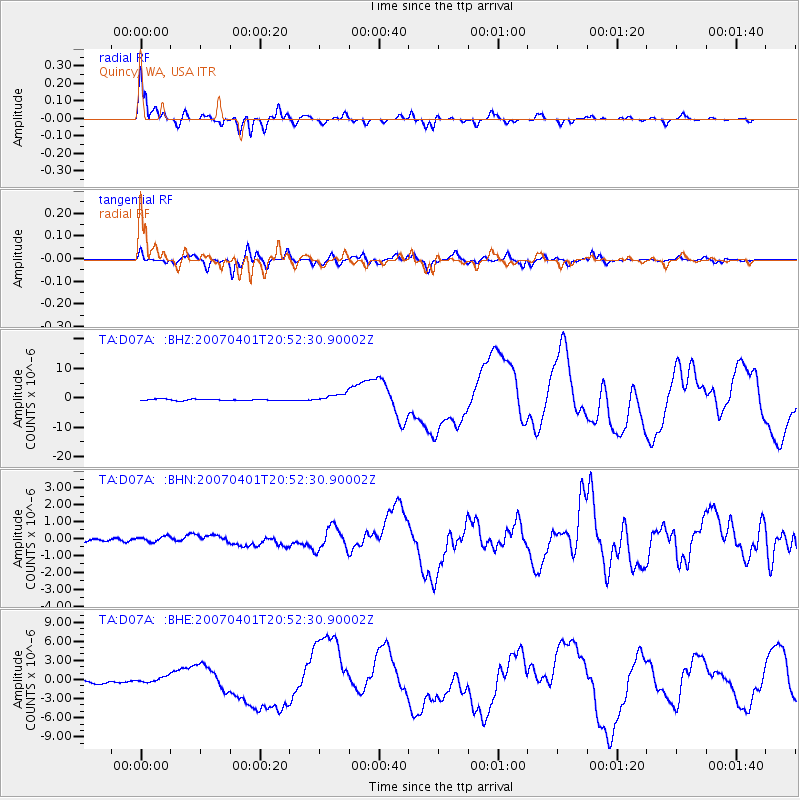
| Radial Match: |
97.47023 % |
| Radial Bump: |
306 |
| Transverse Match: |
91.01117 % |
| Transverse Bump: |
400 |
| SOD ConfigId: |
2564 |
| Insert Time: |
2010-03-07 03:25:42.741 +0000 |
| GWidth: |
2.5 |
| Max Bumps: |
400 |
| Tol: |
0.001 |
|
Signal To Noise
| Channel | StoN | STA | LTA |
| TA:D07A: :BHN:20070401T20:52:30.90002Z | 1.7732998 | 1.7362805E-7 | 9.7912405E-8 |
| TA:D07A: :BHE:20070401T20:52:30.90002Z | 3.16411 | 5.1378254E-7 | 1.6237823E-7 |
| TA:D07A: :BHZ:20070401T20:52:30.90002Z | 7.1951637 | 1.5138705E-6 | 2.1040113E-7 |
| Arrivals |
| Ps | 7.4 SECOND |
| PpPs | 23 SECOND |
| PsPs/PpSs | 31 SECOND |


