You are here: Home > Network List > TA - USArray Transportable Network (new EarthScope stations) Stations List
> Station D07A Quincy, WA, USA > Earthquake Result Viewer
D07A Quincy, WA, USA - Earthquake Result Viewer
| Earthquake location: |
Kuril Islands |
| Earthquake latitude/longitude: |
46.6/153.3 |
| Earthquake time(UTC): |
2006/11/15 (319) 11:14:13 GMT |
| Earthquake Depth: |
10 km |
| Earthquake Magnitude: |
6.5 MB, 7.8 MS, 8.3 MW, 7.9 MW |
| Earthquake Catalog/Contributor: |
WHDF/NEIC |
|
| Network: |
TA USArray Transportable Network (new EarthScope stations) |
| Station: |
D07A Quincy, WA, USA |
| Lat/Lon: |
47.19 N/119.97 W |
| Elevation: |
453 m |
|
| Distance: |
56.2 deg |
| Az: |
55.017 deg |
| Baz: |
304.055 deg |
| Ray Param: |
0.06429329 |
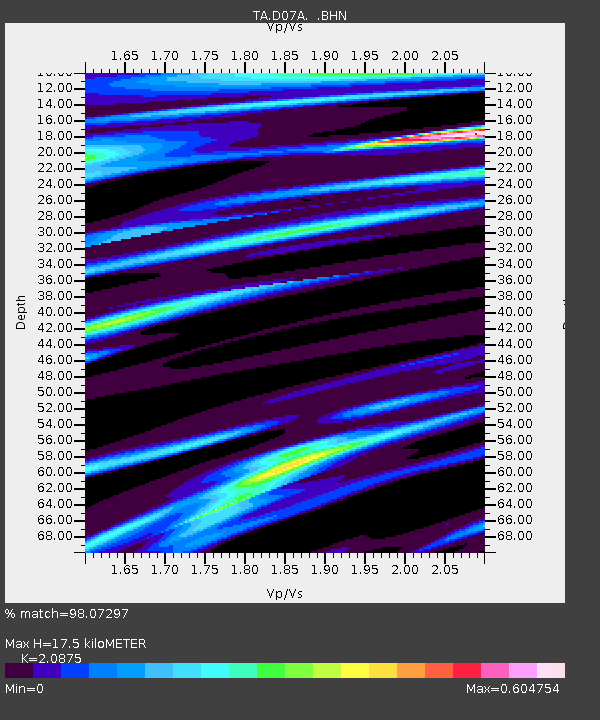
| Estimated Moho Depth: |
17.5 km |
| Estimated Crust Vp/Vs: |
2.09 |
| Assumed Crust Vp: |
6.419 km/s |
| Estimated Crust Vs: |
3.075 km/s |
| Estimated Crust Poisson's Ratio: |
0.35 |
|
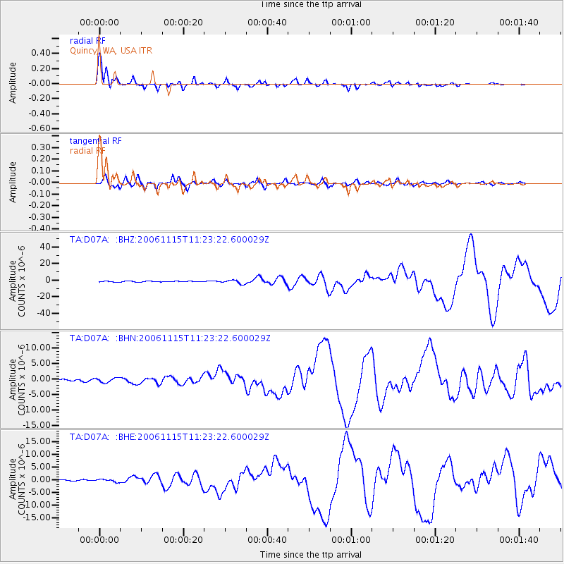
| Radial Match: |
98.07297 % |
| Radial Bump: |
369 |
| Transverse Match: |
86.43049 % |
| Transverse Bump: |
400 |
| SOD ConfigId: |
2564 |
| Insert Time: |
2010-03-07 03:25:47.967 +0000 |
| GWidth: |
2.5 |
| Max Bumps: |
400 |
| Tol: |
0.001 |
|
Signal To Noise
| Channel | StoN | STA | LTA |
| TA:D07A: :BHN:20061115T11:23:22.600029Z | 1.7309567 | 7.174896E-7 | 4.1450468E-7 |
| TA:D07A: :BHE:20061115T11:23:22.600029Z | 0.9877199 | 4.995787E-7 | 5.0578984E-7 |
| TA:D07A: :BHZ:20061115T11:23:22.600029Z | 4.4529595 | 2.3073642E-6 | 5.181642E-7 |
| Arrivals |
| Ps | 3.1 SECOND |
| PpPs | 8.1 SECOND |
| PsPs/PpSs | 11 SECOND |


