You are here: Home > Network List > TA - USArray Transportable Network (new EarthScope stations) Stations List
> Station T13A Saint George, UT, USA > Earthquake Result Viewer
T13A Saint George, UT, USA - Earthquake Result Viewer
| Earthquake location: |
Northern Chile |
| Earthquake latitude/longitude: |
-22.2/-69.9 |
| Earthquake time(UTC): |
2007/11/14 (318) 15:40:50 GMT |
| Earthquake Depth: |
40 km |
| Earthquake Magnitude: |
6.7 MB, 7.4 MS, 7.7 MW, 7.4 ME |
| Earthquake Catalog/Contributor: |
WHDF/NEIC |
|
| Network: |
TA USArray Transportable Network (new EarthScope stations) |
| Station: |
T13A Saint George, UT, USA |
| Lat/Lon: |
37.02 N/113.91 W |
| Elevation: |
878 m |
|
| Distance: |
72.1 deg |
| Az: |
324.233 deg |
| Baz: |
137.425 deg |
| Ray Param: |
0.053825676 |
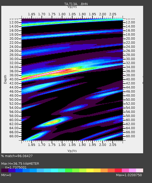
| Estimated Moho Depth: |
36.75 km |
| Estimated Crust Vp/Vs: |
1.74 |
| Assumed Crust Vp: |
6.194 km/s |
| Estimated Crust Vs: |
3.565 km/s |
| Estimated Crust Poisson's Ratio: |
0.25 |
|
| Radial Match: |
96.06427 % |
| Radial Bump: |
400 |
| Transverse Match: |
91.05321 % |
| Transverse Bump: |
400 |
| SOD ConfigId: |
2564 |
| Insert Time: |
2010-03-07 03:26:14.274 +0000 |
| GWidth: |
2.5 |
| Max Bumps: |
400 |
| Tol: |
0.001 |
|

Signal To Noise
| Channel | StoN | STA | LTA |
| TA:T13A: :BHN:20071114T15:51:39.774019Z | 6.998491 | 1.3794365E-6 | 1.9710485E-7 |
| TA:T13A: :BHE:20071114T15:51:39.774019Z | 5.141924 | 7.5949424E-7 | 1.4770625E-7 |
| TA:T13A: :BHZ:20071114T15:51:39.774019Z | 25.901867 | 4.2516754E-6 | 1.6414552E-7 |
| Arrivals |
| Ps | 4.5 SECOND |
| PpPs | 16 SECOND |
| PsPs/PpSs | 20 SECOND |


