You are here: Home > Network List > G - GEOSCOPE Stations List
> Station MPG Montagne des Peres, French Guyana > Earthquake Result Viewer
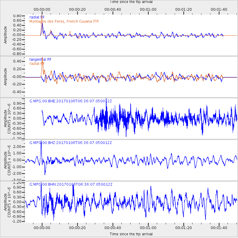
MPG Montagne des Peres, French Guyana - Earthquake Result Viewer
*The percent match for this event was below the threshold and hence no stack was calculated.
| Earthquake location: |
Chile-Bolivia Border Region |
| Earthquake latitude/longitude: |
-22.4/-67.7 |
| Earthquake time(UTC): |
2017/01/06 (006) 06:30:33 GMT |
| Earthquake Depth: |
142 km |
| Earthquake Magnitude: |
5.7 mb |
| Earthquake Catalog/Contributor: |
NEIC PDE/us |
|
| Network: |
G GEOSCOPE |
| Station: |
MPG Montagne des Peres, French Guyana |
| Lat/Lon: |
5.11 N/52.64 W |
| Elevation: |
147 m |
|
| Distance: |
31.0 deg |
| Az: |
30.099 deg |
| Baz: |
207.779 deg |
| Ray Param: |
$rayparam |
*The percent match for this event was below the threshold and hence was not used in the summary stack. |
|
| Radial Match: |
71.98656 % |
| Radial Bump: |
366 |
| Transverse Match: |
60.259083 % |
| Transverse Bump: |
400 |
| SOD ConfigId: |
1943534 |
| Insert Time: |
2017-01-20 06:32:31.552 +0000 |
| GWidth: |
2.5 |
| Max Bumps: |
400 |
| Tol: |
0.001 |
|
Signal To Noise
| Channel | StoN | STA | LTA |
| G:MPG:00:BHZ:20170106T06:36:07.050012Z | 4.549257 | 9.961902E-7 | 2.1897867E-7 |
| G:MPG:00:BHN:20170106T06:36:07.050012Z | 1.9346533 | 4.9673775E-7 | 2.5675803E-7 |
| G:MPG:00:BHE:20170106T06:36:07.050012Z | 1.8968378 | 3.2947406E-7 | 1.7369649E-7 |
| Arrivals |
| Ps | |
| PpPs | |
| PsPs/PpSs | |


