You are here: Home > Network List > TA - USArray Transportable Network (new EarthScope stations) Stations List
> Station T13A Saint George, UT, USA > Earthquake Result Viewer
T13A Saint George, UT, USA - Earthquake Result Viewer
| Earthquake location: |
Southeast Of Loyalty Islands |
| Earthquake latitude/longitude: |
-21.2/169.4 |
| Earthquake time(UTC): |
2007/09/28 (271) 01:01:48 GMT |
| Earthquake Depth: |
10 km |
| Earthquake Magnitude: |
5.8 MB, 6.4 MS, 6.3 MW, 6.2 MW |
| Earthquake Catalog/Contributor: |
WHDF/NEIC |
|
| Network: |
TA USArray Transportable Network (new EarthScope stations) |
| Station: |
T13A Saint George, UT, USA |
| Lat/Lon: |
37.02 N/113.91 W |
| Elevation: |
878 m |
|
| Distance: |
92.5 deg |
| Az: |
51.239 deg |
| Baz: |
245.379 deg |
| Ray Param: |
0.0414399 |
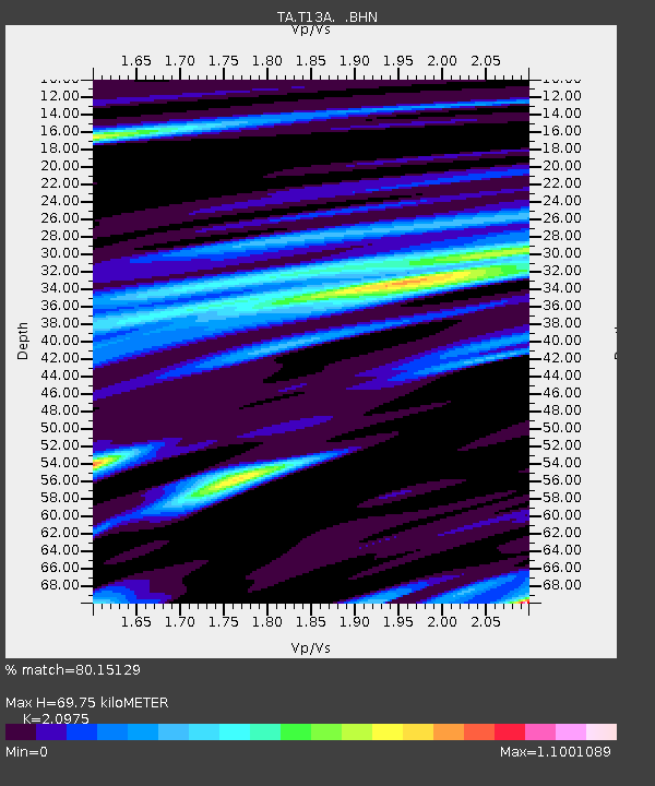
| Estimated Moho Depth: |
69.75 km |
| Estimated Crust Vp/Vs: |
2.10 |
| Assumed Crust Vp: |
6.194 km/s |
| Estimated Crust Vs: |
2.953 km/s |
| Estimated Crust Poisson's Ratio: |
0.35 |
|
| Radial Match: |
80.15129 % |
| Radial Bump: |
400 |
| Transverse Match: |
72.21137 % |
| Transverse Bump: |
400 |
| SOD ConfigId: |
2564 |
| Insert Time: |
2010-03-07 03:26:22.378 +0000 |
| GWidth: |
2.5 |
| Max Bumps: |
400 |
| Tol: |
0.001 |
|
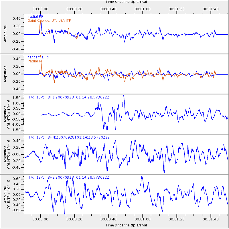
Signal To Noise
| Channel | StoN | STA | LTA |
| TA:T13A: :BHN:20070928T01:14:28.573022Z | 1.8548145 | 1.8717256E-7 | 1.0091174E-7 |
| TA:T13A: :BHE:20070928T01:14:28.573022Z | 1.9182694 | 2.5129424E-7 | 1.3100049E-7 |
| TA:T13A: :BHZ:20070928T01:14:28.573022Z | 5.044279 | 4.5853628E-7 | 9.090225E-8 |
| Arrivals |
| Ps | 13 SECOND |
| PpPs | 34 SECOND |
| PsPs/PpSs | 47 SECOND |


