You are here: Home > Network List > TA - USArray Transportable Network (new EarthScope stations) Stations List
> Station T13A Saint George, UT, USA > Earthquake Result Viewer
T13A Saint George, UT, USA - Earthquake Result Viewer
| Earthquake location: |
Tonga Islands |
| Earthquake latitude/longitude: |
-17.5/-174.3 |
| Earthquake time(UTC): |
2007/08/26 (238) 12:37:31 GMT |
| Earthquake Depth: |
127 km |
| Earthquake Magnitude: |
5.9 MB, 6.1 MW |
| Earthquake Catalog/Contributor: |
WHDF/NEIC |
|
| Network: |
TA USArray Transportable Network (new EarthScope stations) |
| Station: |
T13A Saint George, UT, USA |
| Lat/Lon: |
37.02 N/113.91 W |
| Elevation: |
878 m |
|
| Distance: |
78.6 deg |
| Az: |
45.252 deg |
| Baz: |
237.886 deg |
| Ray Param: |
0.049257193 |
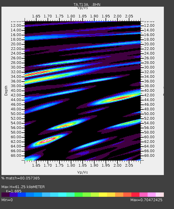
| Estimated Moho Depth: |
61.25 km |
| Estimated Crust Vp/Vs: |
1.70 |
| Assumed Crust Vp: |
6.194 km/s |
| Estimated Crust Vs: |
3.654 km/s |
| Estimated Crust Poisson's Ratio: |
0.23 |
|
| Radial Match: |
80.057365 % |
| Radial Bump: |
400 |
| Transverse Match: |
77.577644 % |
| Transverse Bump: |
400 |
| SOD ConfigId: |
2564 |
| Insert Time: |
2010-03-07 03:26:30.399 +0000 |
| GWidth: |
2.5 |
| Max Bumps: |
400 |
| Tol: |
0.001 |
|

Signal To Noise
| Channel | StoN | STA | LTA |
| TA:T13A: :BHN:20070826T12:48:47.59802Z | 3.461032 | 3.1474158E-7 | 9.0938656E-8 |
| TA:T13A: :BHE:20070826T12:48:47.59802Z | 3.9928758 | 4.703544E-7 | 1.1779841E-7 |
| TA:T13A: :BHZ:20070826T12:48:47.59802Z | 10.278192 | 1.2068565E-6 | 1.17419134E-7 |
| Arrivals |
| Ps | 7.1 SECOND |
| PpPs | 26 SECOND |
| PsPs/PpSs | 33 SECOND |


