You are here: Home > Network List > TA - USArray Transportable Network (new EarthScope stations) Stations List
> Station T13A Saint George, UT, USA > Earthquake Result Viewer
T13A Saint George, UT, USA - Earthquake Result Viewer
| Earthquake location: |
Jujuy Province, Argentina |
| Earthquake latitude/longitude: |
-22.2/-65.8 |
| Earthquake time(UTC): |
2007/07/21 (202) 15:34:52 GMT |
| Earthquake Depth: |
290 km |
| Earthquake Magnitude: |
5.8 MB, 6.4 MW, 6.3 MW |
| Earthquake Catalog/Contributor: |
WHDF/NEIC |
|
| Network: |
TA USArray Transportable Network (new EarthScope stations) |
| Station: |
T13A Saint George, UT, USA |
| Lat/Lon: |
37.02 N/113.91 W |
| Elevation: |
878 m |
|
| Distance: |
74.3 deg |
| Az: |
321.751 deg |
| Baz: |
134.185 deg |
| Ray Param: |
0.051613808 |
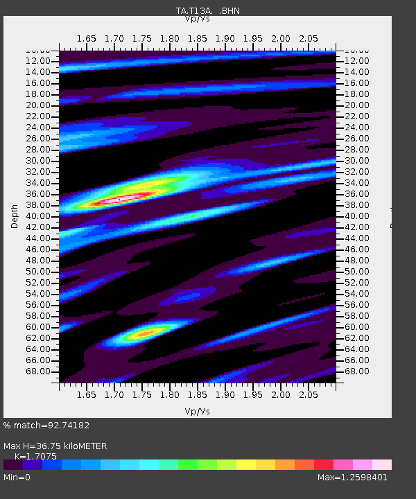
| Estimated Moho Depth: |
36.75 km |
| Estimated Crust Vp/Vs: |
1.71 |
| Assumed Crust Vp: |
6.194 km/s |
| Estimated Crust Vs: |
3.628 km/s |
| Estimated Crust Poisson's Ratio: |
0.24 |
|
| Radial Match: |
92.74182 % |
| Radial Bump: |
400 |
| Transverse Match: |
85.67999 % |
| Transverse Bump: |
400 |
| SOD ConfigId: |
2564 |
| Insert Time: |
2010-03-07 03:26:37.140 +0000 |
| GWidth: |
2.5 |
| Max Bumps: |
400 |
| Tol: |
0.001 |
|

Signal To Noise
| Channel | StoN | STA | LTA |
| TA:T13A: :BHN:20070721T15:45:27.500024Z | 1.5110825 | 1.3686112E-7 | 9.057157E-8 |
| TA:T13A: :BHE:20070721T15:45:27.500024Z | 1.4090282 | 8.345177E-8 | 5.9226473E-8 |
| TA:T13A: :BHZ:20070721T15:45:27.500024Z | 6.6819196 | 2.9886544E-7 | 4.4727482E-8 |
| Arrivals |
| Ps | 4.3 SECOND |
| PpPs | 16 SECOND |
| PsPs/PpSs | 20 SECOND |


