You are here: Home > Network List > TA - USArray Transportable Network (new EarthScope stations) Stations List
> Station T13A Saint George, UT, USA > Earthquake Result Viewer
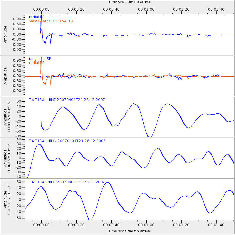
T13A Saint George, UT, USA - Earthquake Result Viewer

| Earthquake location: |
Solomon Islands |
| Earthquake latitude/longitude: |
-7.3/155.7 |
| Earthquake time(UTC): |
2007/04/01 (091) 21:15:22 GMT |
| Earthquake Depth: |
10 km |
| Earthquake Magnitude: |
6.0 MB |
| Earthquake Catalog/Contributor: |
WHDF/NEIC |
|
| Network: |
TA USArray Transportable Network (new EarthScope stations) |
| Station: |
T13A Saint George, UT, USA |
| Lat/Lon: |
37.02 N/113.91 W |
| Elevation: |
878 m |
|
| Distance: |
94.7 deg |
| Az: |
53.419 deg |
| Baz: |
264.426 deg |
| Ray Param: |
0.040986605 |
| Estimated Moho Depth: |
58.25 km |
| Estimated Crust Vp/Vs: |
1.64 |
| Assumed Crust Vp: |
6.194 km/s |
| Estimated Crust Vs: |
3.777 km/s |
| Estimated Crust Poisson's Ratio: |
0.20 |
|
| Radial Match: |
93.11687 % |
| Radial Bump: |
393 |
| Transverse Match: |
57.228104 % |
| Transverse Bump: |
398 |
| SOD ConfigId: |
2564 |
| Insert Time: |
2010-03-07 03:26:56.254 +0000 |
| GWidth: |
2.5 |
| Max Bumps: |
400 |
| Tol: |
0.001 |
|
Signal To Noise
| Channel | StoN | STA | LTA |
| TA:T13A: :BHN:20070401T21:28:12.200Z | 1.1552529 | 2.271708E-5 | 1.9664163E-5 |
| TA:T13A: :BHE:20070401T21:28:12.200Z | 1.6667752 | 4.135054E-5 | 2.4808707E-5 |
| TA:T13A: :BHZ:20070401T21:28:12.200Z | 1.3434176 | 4.3466505E-5 | 3.235517E-5 |
| Arrivals |
| Ps | 6.1 SECOND |
| PpPs | 24 SECOND |
| PsPs/PpSs | 30 SECOND |


