You are here: Home > Network List > TA - USArray Transportable Network (new EarthScope stations) Stations List
> Station B18K Kokolik River, AK, USA > Earthquake Result Viewer
B18K Kokolik River, AK, USA - Earthquake Result Viewer
*The percent match for this event was below the threshold and hence no stack was calculated.
| Earthquake location: |
Mariana Islands |
| Earthquake latitude/longitude: |
17.6/145.5 |
| Earthquake time(UTC): |
2019/08/22 (234) 11:02:40 GMT |
| Earthquake Depth: |
512 km |
| Earthquake Magnitude: |
5.4 Mww |
| Earthquake Catalog/Contributor: |
NEIC PDE/us |
|
| Network: |
TA USArray Transportable Network (new EarthScope stations) |
| Station: |
B18K Kokolik River, AK, USA |
| Lat/Lon: |
69.36 N/161.80 W |
| Elevation: |
222 m |
|
| Distance: |
60.9 deg |
| Az: |
18.826 deg |
| Baz: |
240.243 deg |
| Ray Param: |
$rayparam |
*The percent match for this event was below the threshold and hence was not used in the summary stack. |
|
| Radial Match: |
59.14176 % |
| Radial Bump: |
400 |
| Transverse Match: |
57.222336 % |
| Transverse Bump: |
400 |
| SOD ConfigId: |
19053131 |
| Insert Time: |
2019-09-05 11:09:41.881 +0000 |
| GWidth: |
2.5 |
| Max Bumps: |
400 |
| Tol: |
0.001 |
|
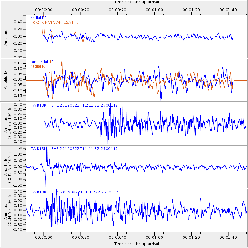
Signal To Noise
| Channel | StoN | STA | LTA |
| TA:B18K: :BHZ:20190822T11:11:32.250011Z | 7.314922 | 6.0728615E-7 | 8.302018E-8 |
| TA:B18K: :BHN:20190822T11:11:32.250011Z | 1.8178064 | 1.3424844E-7 | 7.385189E-8 |
| TA:B18K: :BHE:20190822T11:11:32.250011Z | 2.2529695 | 1.4516058E-7 | 6.4430786E-8 |
| Arrivals |
| Ps | |
| PpPs | |
| PsPs/PpSs | |


