You are here: Home > Network List > IU - Global Seismograph Network (GSN - IRIS/USGS) Stations List
> Station RSSD Black Hills, South Dakota, USA > Earthquake Result Viewer
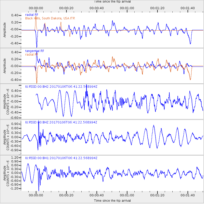
RSSD Black Hills, South Dakota, USA - Earthquake Result Viewer
*The percent match for this event was below the threshold and hence no stack was calculated.
| Earthquake location: |
Chile-Bolivia Border Region |
| Earthquake latitude/longitude: |
-22.4/-67.7 |
| Earthquake time(UTC): |
2017/01/06 (006) 06:30:33 GMT |
| Earthquake Depth: |
142 km |
| Earthquake Magnitude: |
5.7 mb |
| Earthquake Catalog/Contributor: |
NEIC PDE/us |
|
| Network: |
IU Global Seismograph Network (GSN - IRIS/USGS) |
| Station: |
RSSD Black Hills, South Dakota, USA |
| Lat/Lon: |
44.12 N/104.04 W |
| Elevation: |
2090 m |
|
| Distance: |
74.1 deg |
| Az: |
333.641 deg |
| Baz: |
145.202 deg |
| Ray Param: |
$rayparam |
*The percent match for this event was below the threshold and hence was not used in the summary stack. |
|
| Radial Match: |
56.955822 % |
| Radial Bump: |
400 |
| Transverse Match: |
56.148605 % |
| Transverse Bump: |
400 |
| SOD ConfigId: |
1943534 |
| Insert Time: |
2017-01-20 06:33:42.710 +0000 |
| GWidth: |
2.5 |
| Max Bumps: |
400 |
| Tol: |
0.001 |
|
Signal To Noise
| Channel | StoN | STA | LTA |
| IU:RSSD:00:BHZ:20170106T06:41:22.568994Z | 2.4997914 | 3.8929863E-7 | 1.5573244E-7 |
| IU:RSSD:00:BH1:20170106T06:41:22.568994Z | 2.2826457 | 5.0780005E-7 | 2.2246118E-7 |
| IU:RSSD:00:BH2:20170106T06:41:22.568994Z | 0.9098218 | 2.2208779E-7 | 2.441003E-7 |
| Arrivals |
| Ps | |
| PpPs | |
| PsPs/PpSs | |


