You are here: Home > Network List > TA - USArray Transportable Network (new EarthScope stations) Stations List
> Station Q09A Carvers, NV, USA > Earthquake Result Viewer
Q09A Carvers, NV, USA - Earthquake Result Viewer
| Earthquake location: |
Solomon Islands |
| Earthquake latitude/longitude: |
-10.9/162.1 |
| Earthquake time(UTC): |
2007/11/27 (331) 11:49:58 GMT |
| Earthquake Depth: |
16 km |
| Earthquake Magnitude: |
5.9 MB, 6.7 MS, 6.6 MW, 6.4 MW |
| Earthquake Catalog/Contributor: |
WHDF/NEIC |
|
| Network: |
TA USArray Transportable Network (new EarthScope stations) |
| Station: |
Q09A Carvers, NV, USA |
| Lat/Lon: |
38.83 N/117.18 W |
| Elevation: |
1704 m |
|
| Distance: |
89.6 deg |
| Az: |
50.417 deg |
| Baz: |
255.71 deg |
| Ray Param: |
0.041730173 |
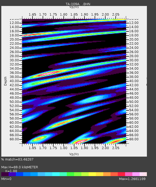
| Estimated Moho Depth: |
69.0 km |
| Estimated Crust Vp/Vs: |
1.88 |
| Assumed Crust Vp: |
6.276 km/s |
| Estimated Crust Vs: |
3.338 km/s |
| Estimated Crust Poisson's Ratio: |
0.30 |
|
| Radial Match: |
83.46287 % |
| Radial Bump: |
400 |
| Transverse Match: |
69.06624 % |
| Transverse Bump: |
400 |
| SOD ConfigId: |
2564 |
| Insert Time: |
2010-03-07 03:27:09.087 +0000 |
| GWidth: |
2.5 |
| Max Bumps: |
400 |
| Tol: |
0.001 |
|
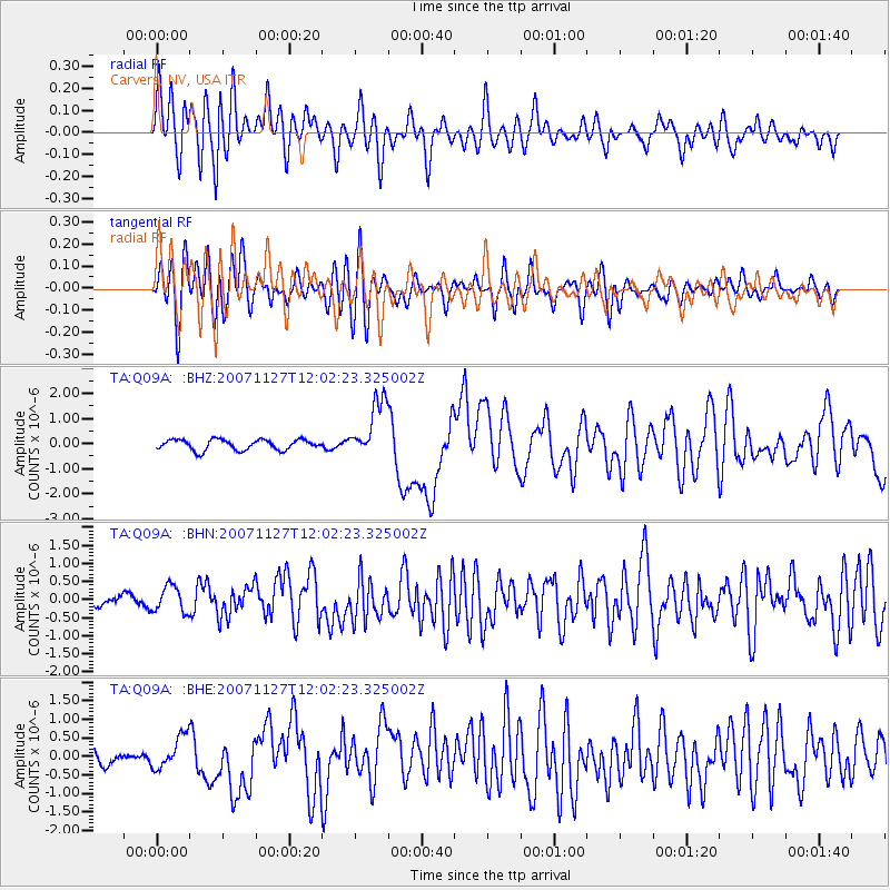
Signal To Noise
| Channel | StoN | STA | LTA |
| TA:Q09A: :BHN:20071127T12:02:23.325002Z | 2.2742524 | 3.6805383E-7 | 1.6183509E-7 |
| TA:Q09A: :BHE:20071127T12:02:23.325002Z | 1.6489136 | 4.275271E-7 | 2.5927807E-7 |
| TA:Q09A: :BHZ:20071127T12:02:23.325002Z | 5.5979643 | 1.1679851E-6 | 2.0864462E-7 |
| Arrivals |
| Ps | 9.9 SECOND |
| PpPs | 31 SECOND |
| PsPs/PpSs | 41 SECOND |


