You are here: Home > Network List > TA - USArray Transportable Network (new EarthScope stations) Stations List
> Station Q09A Carvers, NV, USA > Earthquake Result Viewer
Q09A Carvers, NV, USA - Earthquake Result Viewer
| Earthquake location: |
Northern Chile |
| Earthquake latitude/longitude: |
-22.2/-69.9 |
| Earthquake time(UTC): |
2007/11/14 (318) 15:40:50 GMT |
| Earthquake Depth: |
40 km |
| Earthquake Magnitude: |
6.7 MB, 7.4 MS, 7.7 MW, 7.4 ME |
| Earthquake Catalog/Contributor: |
WHDF/NEIC |
|
| Network: |
TA USArray Transportable Network (new EarthScope stations) |
| Station: |
Q09A Carvers, NV, USA |
| Lat/Lon: |
38.83 N/117.18 W |
| Elevation: |
1704 m |
|
| Distance: |
75.2 deg |
| Az: |
323.584 deg |
| Baz: |
135.237 deg |
| Ray Param: |
0.051773746 |
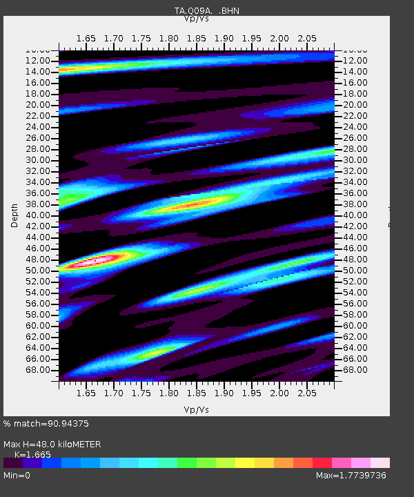
| Estimated Moho Depth: |
48.0 km |
| Estimated Crust Vp/Vs: |
1.66 |
| Assumed Crust Vp: |
6.276 km/s |
| Estimated Crust Vs: |
3.769 km/s |
| Estimated Crust Poisson's Ratio: |
0.22 |
|
| Radial Match: |
90.94375 % |
| Radial Bump: |
400 |
| Transverse Match: |
85.35303 % |
| Transverse Bump: |
400 |
| SOD ConfigId: |
2564 |
| Insert Time: |
2010-03-07 03:27:12.698 +0000 |
| GWidth: |
2.5 |
| Max Bumps: |
400 |
| Tol: |
0.001 |
|
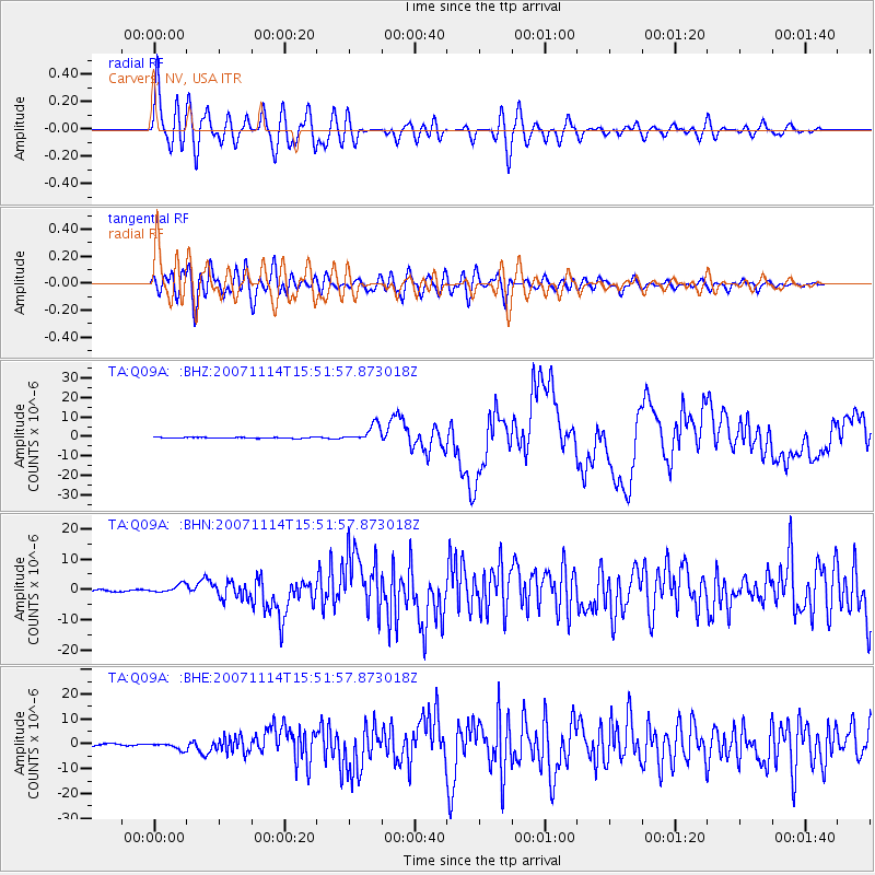
Signal To Noise
| Channel | StoN | STA | LTA |
| TA:Q09A: :BHN:20071114T15:51:57.873018Z | 3.777915 | 1.3810364E-6 | 3.655552E-7 |
| TA:Q09A: :BHE:20071114T15:51:57.873018Z | 4.1688437 | 1.3495886E-6 | 3.2373214E-7 |
| TA:Q09A: :BHZ:20071114T15:51:57.873018Z | 19.773132 | 4.3055147E-6 | 2.1774571E-7 |
| Arrivals |
| Ps | 5.3 SECOND |
| PpPs | 20 SECOND |
| PsPs/PpSs | 25 SECOND |


