You are here: Home > Network List > TA - USArray Transportable Network (new EarthScope stations) Stations List
> Station Q09A Carvers, NV, USA > Earthquake Result Viewer
Q09A Carvers, NV, USA - Earthquake Result Viewer
| Earthquake location: |
Near West Coast Of Colombia |
| Earthquake latitude/longitude: |
3.0/-78.0 |
| Earthquake time(UTC): |
2007/09/10 (253) 01:49:14 GMT |
| Earthquake Depth: |
31 km |
| Earthquake Magnitude: |
6.1 MB, 6.7 MS, 6.8 MW |
| Earthquake Catalog/Contributor: |
WHDF/NEIC |
|
| Network: |
TA USArray Transportable Network (new EarthScope stations) |
| Station: |
Q09A Carvers, NV, USA |
| Lat/Lon: |
38.83 N/117.18 W |
| Elevation: |
1704 m |
|
| Distance: |
50.5 deg |
| Az: |
320.188 deg |
| Baz: |
125.046 deg |
| Ray Param: |
0.067981586 |
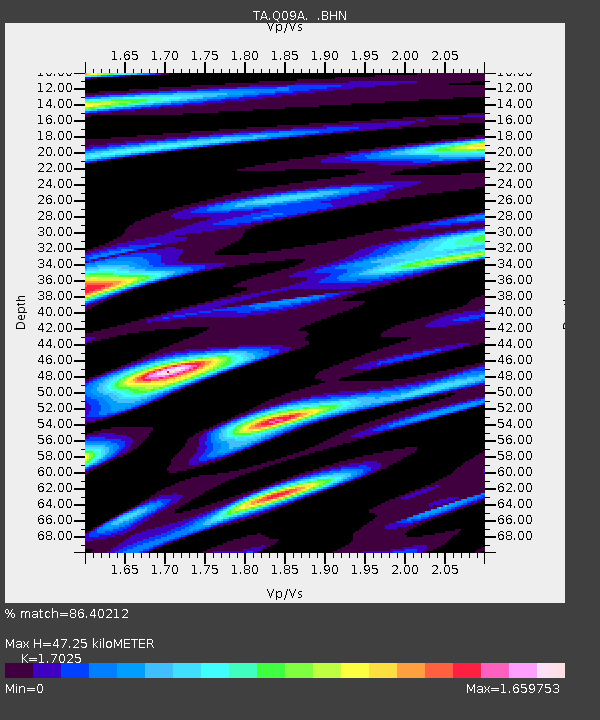
| Estimated Moho Depth: |
47.25 km |
| Estimated Crust Vp/Vs: |
1.70 |
| Assumed Crust Vp: |
6.276 km/s |
| Estimated Crust Vs: |
3.686 km/s |
| Estimated Crust Poisson's Ratio: |
0.24 |
|
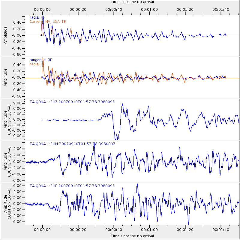
| Radial Match: |
86.40212 % |
| Radial Bump: |
400 |
| Transverse Match: |
82.65579 % |
| Transverse Bump: |
400 |
| SOD ConfigId: |
2564 |
| Insert Time: |
2010-03-07 03:27:24.643 +0000 |
| GWidth: |
2.5 |
| Max Bumps: |
400 |
| Tol: |
0.001 |
|
Signal To Noise
| Channel | StoN | STA | LTA |
| TA:Q09A: :BHN:20070910T01:57:38.398009Z | 2.0145676 | 4.4069301E-7 | 2.1875314E-7 |
| TA:Q09A: :BHE:20070910T01:57:38.398009Z | 2.1178417 | 5.4541437E-7 | 2.5753312E-7 |
| TA:Q09A: :BHZ:20070910T01:57:38.398009Z | 11.009766 | 1.3376892E-6 | 1.2150025E-7 |
| Arrivals |
| Ps | 5.6 SECOND |
| PpPs | 19 SECOND |
| PsPs/PpSs | 25 SECOND |


