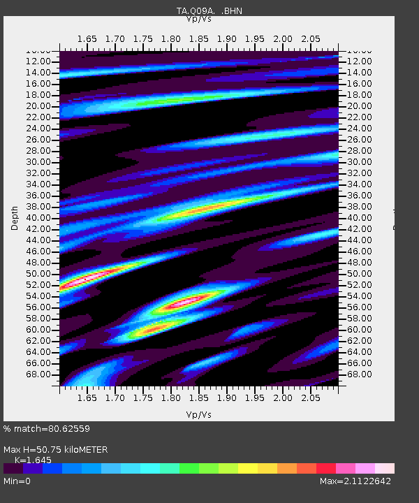
Q09A Carvers, NV, USA - Earthquake Result Viewer
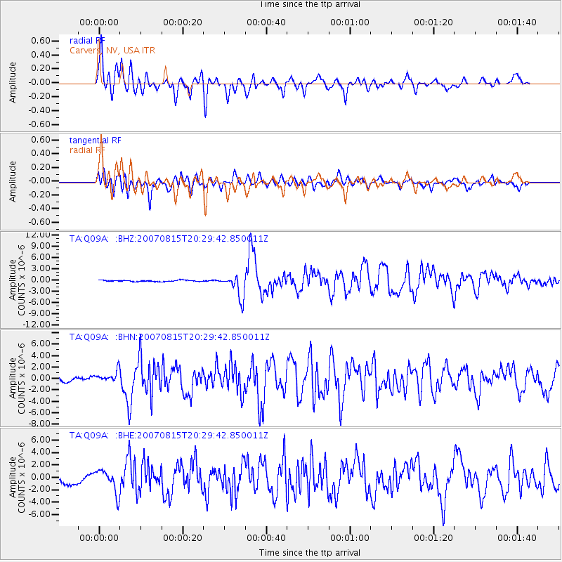
Earthquake location: Andreanof Islands, Aleutian Is.
Earthquake latitude/longitude: 50.3/-177.5
Earthquake time(UTC): 2007/08/15 (227) 20:22:11 GMT
Earthquake Depth: 9.0 km
Earthquake Magnitude: 6.3 MB, 6.2 MS, 6.4 MW, 5.9 ML
Earthquake Catalog/Contributor: WHDF/NEIC
Network: TA USArray Transportable Network (new EarthScope stations)
Station: Q09A Carvers, NV, USA
Lat/Lon: 38.83 N/117.18 W
Elevation: 1704 m
Distance: 43.4 deg
Az: 81.297 deg
Baz: 305.778 deg
Ray Param: 0.07259563
Estimated Moho Depth: 50.75 km
Estimated Crust Vp/Vs: 1.64
Assumed Crust Vp: 6.276 km/s
Estimated Crust Vs: 3.815 km/s
Estimated Crust Poisson's Ratio: 0.21
Radial Match: 80.62559 %
Radial Bump: 400
Transverse Match: 72.152855 %
Transverse Bump: 400
SOD ConfigId: 2564
Insert Time: 2010-03-07 03:27:40.530 +0000
GWidth: 2.5
Max Bumps: 400
Tol: 0.001

Signal To Noise

ChannelStoNSTALTA
TA:Q09A: :BHN:20070815T20:29:42.850011Z2.34121581.021195E-64.3618147E-7
TA:Q09A: :BHE:20070815T20:29:42.850011Z3.4901461.916321E-65.4906616E-7
TA:Q09A: :BHZ:20070815T20:29:42.850011Z19.626853.2017374E-61.6313048E-7
Arrivals
Ps5.6 SECOND
PpPs20 SECOND
PsPs/PpSs26 SECOND