You are here: Home > Network List > TA - USArray Transportable Network (new EarthScope stations) Stations List
> Station Q09A Carvers, NV, USA > Earthquake Result Viewer
Q09A Carvers, NV, USA - Earthquake Result Viewer
| Earthquake location: |
Jujuy Province, Argentina |
| Earthquake latitude/longitude: |
-22.2/-65.8 |
| Earthquake time(UTC): |
2007/07/21 (202) 15:34:52 GMT |
| Earthquake Depth: |
290 km |
| Earthquake Magnitude: |
5.8 MB, 6.4 MW, 6.3 MW |
| Earthquake Catalog/Contributor: |
WHDF/NEIC |
|
| Network: |
TA USArray Transportable Network (new EarthScope stations) |
| Station: |
Q09A Carvers, NV, USA |
| Lat/Lon: |
38.83 N/117.18 W |
| Elevation: |
1704 m |
|
| Distance: |
77.4 deg |
| Az: |
321.288 deg |
| Baz: |
132.068 deg |
| Ray Param: |
0.049538992 |
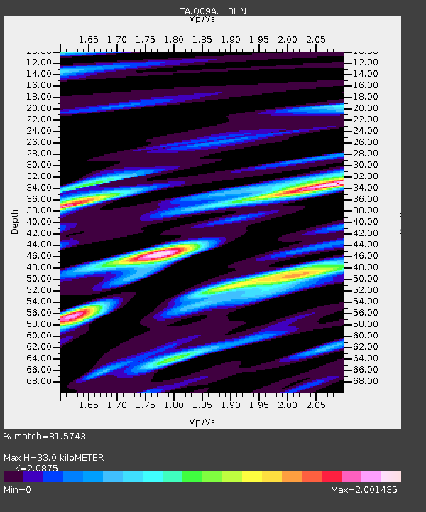
| Estimated Moho Depth: |
33.0 km |
| Estimated Crust Vp/Vs: |
2.09 |
| Assumed Crust Vp: |
6.276 km/s |
| Estimated Crust Vs: |
3.006 km/s |
| Estimated Crust Poisson's Ratio: |
0.35 |
|
| Radial Match: |
81.5743 % |
| Radial Bump: |
400 |
| Transverse Match: |
68.80053 % |
| Transverse Bump: |
400 |
| SOD ConfigId: |
2564 |
| Insert Time: |
2010-03-07 03:27:46.994 +0000 |
| GWidth: |
2.5 |
| Max Bumps: |
400 |
| Tol: |
0.001 |
|
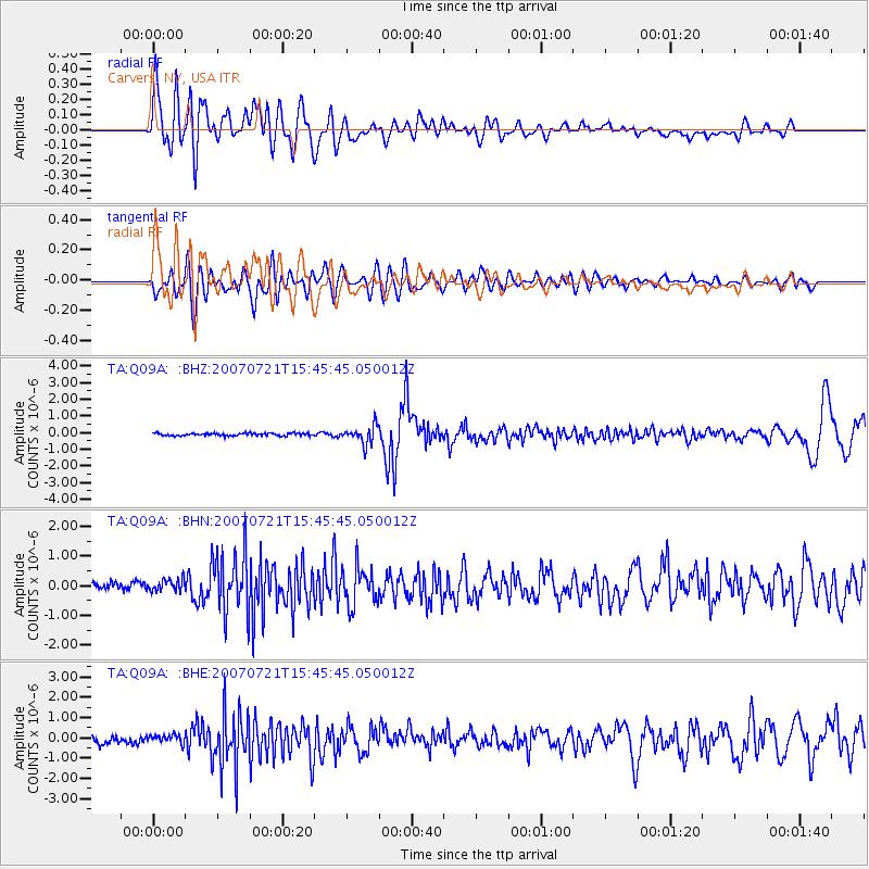
Signal To Noise
| Channel | StoN | STA | LTA |
| TA:Q09A: :BHN:20070721T15:45:45.050012Z | 1.6498784 | 2.1374544E-7 | 1.2955223E-7 |
| TA:Q09A: :BHE:20070721T15:45:45.050012Z | 1.0564301 | 1.9627713E-7 | 1.8579281E-7 |
| TA:Q09A: :BHZ:20070721T15:45:45.050012Z | 7.029545 | 5.30909E-7 | 7.552537E-8 |
| Arrivals |
| Ps | 5.9 SECOND |
| PpPs | 16 SECOND |
| PsPs/PpSs | 22 SECOND |


