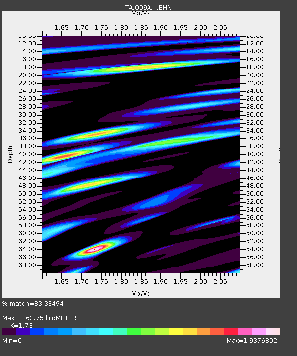
Q09A Carvers, NV, USA - Earthquake Result Viewer
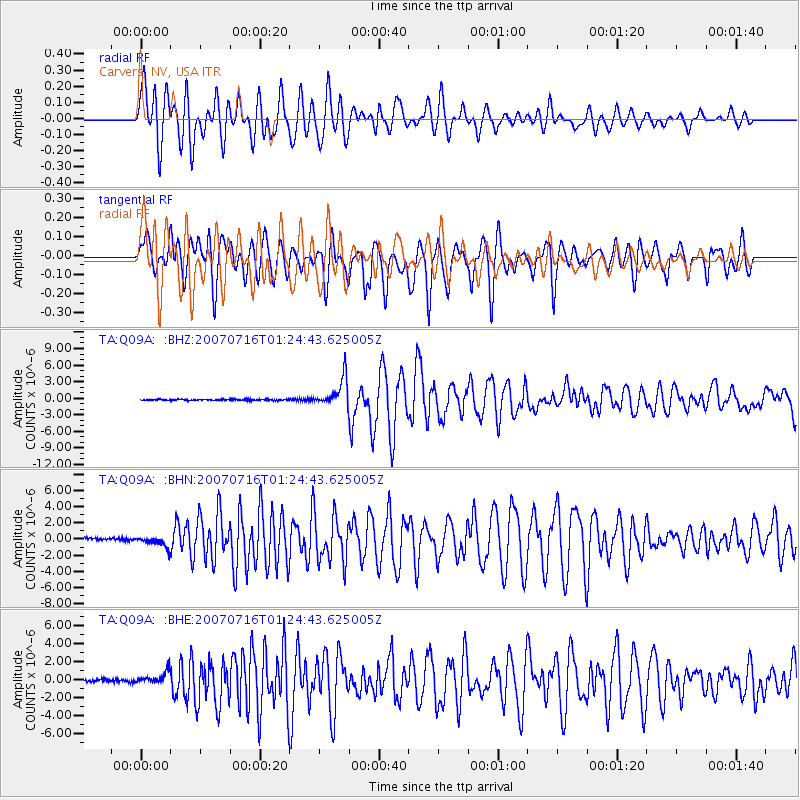
Earthquake location: Near West Coast Of Honshu, Japan
Earthquake latitude/longitude: 37.5/138.4
Earthquake time(UTC): 2007/07/16 (197) 01:13:22 GMT
Earthquake Depth: 12 km
Earthquake Magnitude: 6.5 MB, 6.4 MS, 6.6 MW, 6.5 MW
Earthquake Catalog/Contributor: WHDF/NEIC
Network: TA USArray Transportable Network (new EarthScope stations)
Station: Q09A Carvers, NV, USA
Lat/Lon: 38.83 N/117.18 W
Elevation: 1704 m
Distance: 77.0 deg
Az: 50.936 deg
Baz: 307.787 deg
Ray Param: 0.05060561
Estimated Moho Depth: 63.75 km
Estimated Crust Vp/Vs: 1.73
Assumed Crust Vp: 6.276 km/s
Estimated Crust Vs: 3.628 km/s
Estimated Crust Poisson's Ratio: 0.25
Radial Match: 83.33494 %
Radial Bump: 400
Transverse Match: 81.73092 %
Transverse Bump: 400
SOD ConfigId: 2564
Insert Time: 2010-03-07 03:27:49.883 +0000
GWidth: 2.5
Max Bumps: 400
Tol: 0.001

Signal To Noise

ChannelStoNSTALTA
TA:Q09A: :BHN:20070716T01:24:43.625005Z4.60743576.3091284E-71.3693362E-7
TA:Q09A: :BHE:20070716T01:24:43.625005Z3.7689887.053894E-71.8715619E-7
TA:Q09A: :BHZ:20070716T01:24:43.625005Z25.7539652.535381E-69.844624E-8
Arrivals
Ps7.6 SECOND
PpPs27 SECOND
PsPs/PpSs35 SECOND