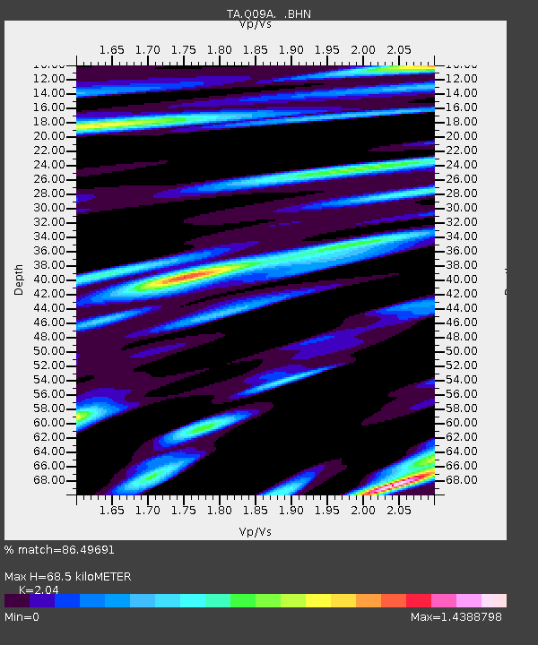
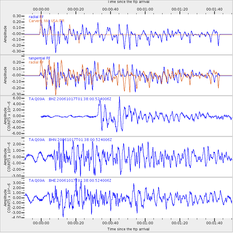
Q09A Carvers, NV, USA - Earthquake Result Viewer

Earthquake location: New Britain Region, P.N.G.
Earthquake latitude/longitude: -5.9/151.0
Earthquake time(UTC): 2006/10/17 (290) 01:25:12 GMT
Earthquake Depth: 32 km
Earthquake Magnitude: 6.4 MB, 6.9 MS, 6.7 MW, 6.6 MW
Earthquake Catalog/Contributor: WHDF/NEIC
Network: TA USArray Transportable Network (new EarthScope stations)
Station: Q09A Carvers, NV, USA
Lat/Lon: 38.83 N/117.18 W
Elevation: 1704 m
Distance: 95.1 deg
Az: 51.6 deg
Baz: 266.57 deg
Ray Param: 0.040864866
Estimated Moho Depth: 68.5 km
Estimated Crust Vp/Vs: 2.04
Assumed Crust Vp: 6.276 km/s
Estimated Crust Vs: 3.076 km/s
Estimated Crust Poisson's Ratio: 0.34
Radial Match: 86.49691 %
Radial Bump: 400
Transverse Match: 83.24428 %
Transverse Bump: 400
SOD ConfigId: 2665
Insert Time: 2010-03-07 03:28:06.319 +0000
GWidth: 2.5
Max Bumps: 400
Tol: 0.001

Signal To Noise

ChannelStoNSTALTA
TA:Q09A: :BHN:20061017T01:38:00.524006Z1.66054984.6388192E-72.7935442E-7
TA:Q09A: :BHE:20061017T01:38:00.524006Z1.43993045.413277E-73.7594017E-7
TA:Q09A: :BHZ:20061017T01:38:00.524006Z12.9444572.2843549E-61.7647359E-7
Arrivals
Ps12 SECOND
PpPs33 SECOND
PsPs/PpSs44 SECOND