You are here: Home > Network List > TA - USArray Transportable Network (new EarthScope stations) Stations List
> Station Q09A Carvers, NV, USA > Earthquake Result Viewer
Q09A Carvers, NV, USA - Earthquake Result Viewer
| Earthquake location: |
Solomon Islands |
| Earthquake latitude/longitude: |
-6.8/155.5 |
| Earthquake time(UTC): |
2006/09/01 (244) 10:18:51 GMT |
| Earthquake Depth: |
38 km |
| Earthquake Magnitude: |
6.3 MB, 6.7 MS, 6.8 MW, 6.7 MW |
| Earthquake Catalog/Contributor: |
WHDF/NEIC |
|
| Network: |
TA USArray Transportable Network (new EarthScope stations) |
| Station: |
Q09A Carvers, NV, USA |
| Lat/Lon: |
38.83 N/117.18 W |
| Elevation: |
1704 m |
|
| Distance: |
92.1 deg |
| Az: |
51.323 deg |
| Baz: |
263.077 deg |
| Ray Param: |
0.04149946 |
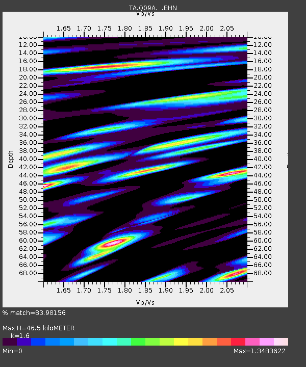
| Estimated Moho Depth: |
46.5 km |
| Estimated Crust Vp/Vs: |
1.60 |
| Assumed Crust Vp: |
6.276 km/s |
| Estimated Crust Vs: |
3.922 km/s |
| Estimated Crust Poisson's Ratio: |
0.18 |
|
| Radial Match: |
83.98156 % |
| Radial Bump: |
400 |
| Transverse Match: |
86.76172 % |
| Transverse Bump: |
400 |
| SOD ConfigId: |
2665 |
| Insert Time: |
2010-03-07 03:28:15.800 +0000 |
| GWidth: |
2.5 |
| Max Bumps: |
400 |
| Tol: |
0.001 |
|
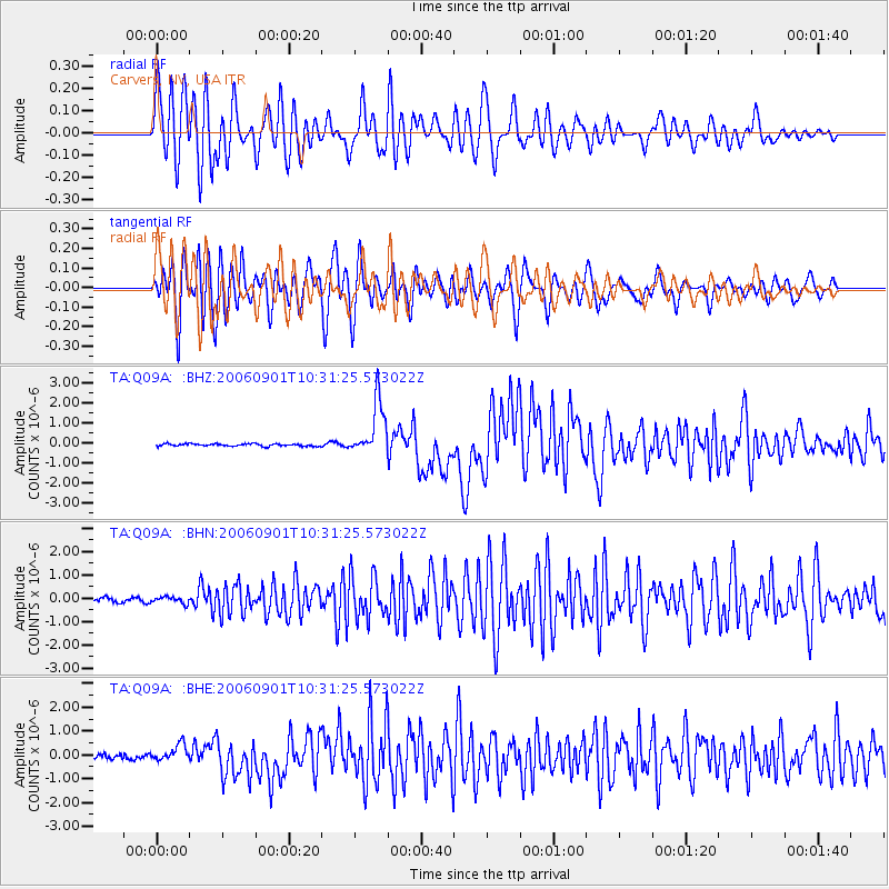
Signal To Noise
| Channel | StoN | STA | LTA |
| TA:Q09A: :BHN:20060901T10:31:25.573022Z | 1.1455542 | 1.4233115E-7 | 1.2424654E-7 |
| TA:Q09A: :BHE:20060901T10:31:25.573022Z | 2.5918915 | 3.5025363E-7 | 1.3513437E-7 |
| TA:Q09A: :BHZ:20060901T10:31:25.573022Z | 22.71256 | 1.3509466E-6 | 5.948015E-8 |
| Arrivals |
| Ps | 4.5 SECOND |
| PpPs | 19 SECOND |
| PsPs/PpSs | 23 SECOND |


