You are here: Home > Network List > TA - USArray Transportable Network (new EarthScope stations) Stations List
> Station Q09A Carvers, NV, USA > Earthquake Result Viewer
Q09A Carvers, NV, USA - Earthquake Result Viewer
| Earthquake location: |
Vanuatu Islands |
| Earthquake latitude/longitude: |
-15.8/167.8 |
| Earthquake time(UTC): |
2006/08/07 (219) 22:18:54 GMT |
| Earthquake Depth: |
141 km |
| Earthquake Magnitude: |
6.0 MB, 6.8 MW, 6.8 MW |
| Earthquake Catalog/Contributor: |
WHDF/NEIC |
|
| Network: |
TA USArray Transportable Network (new EarthScope stations) |
| Station: |
Q09A Carvers, NV, USA |
| Lat/Lon: |
38.83 N/117.18 W |
| Elevation: |
1704 m |
|
| Distance: |
88.5 deg |
| Az: |
49.001 deg |
| Baz: |
248.495 deg |
| Ray Param: |
0.04220841 |
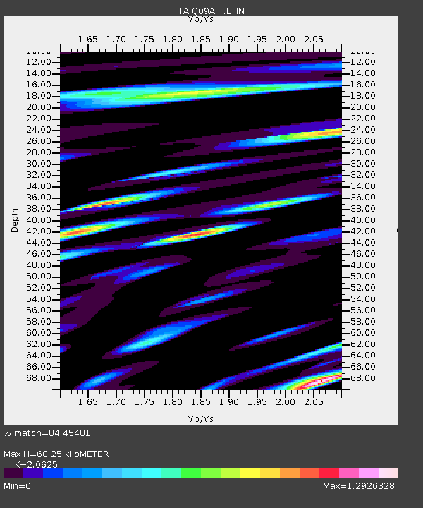
| Estimated Moho Depth: |
68.25 km |
| Estimated Crust Vp/Vs: |
2.06 |
| Assumed Crust Vp: |
6.276 km/s |
| Estimated Crust Vs: |
3.043 km/s |
| Estimated Crust Poisson's Ratio: |
0.35 |
|
| Radial Match: |
84.45481 % |
| Radial Bump: |
400 |
| Transverse Match: |
83.80129 % |
| Transverse Bump: |
400 |
| SOD ConfigId: |
2665 |
| Insert Time: |
2010-03-07 03:28:21.907 +0000 |
| GWidth: |
2.5 |
| Max Bumps: |
400 |
| Tol: |
0.001 |
|
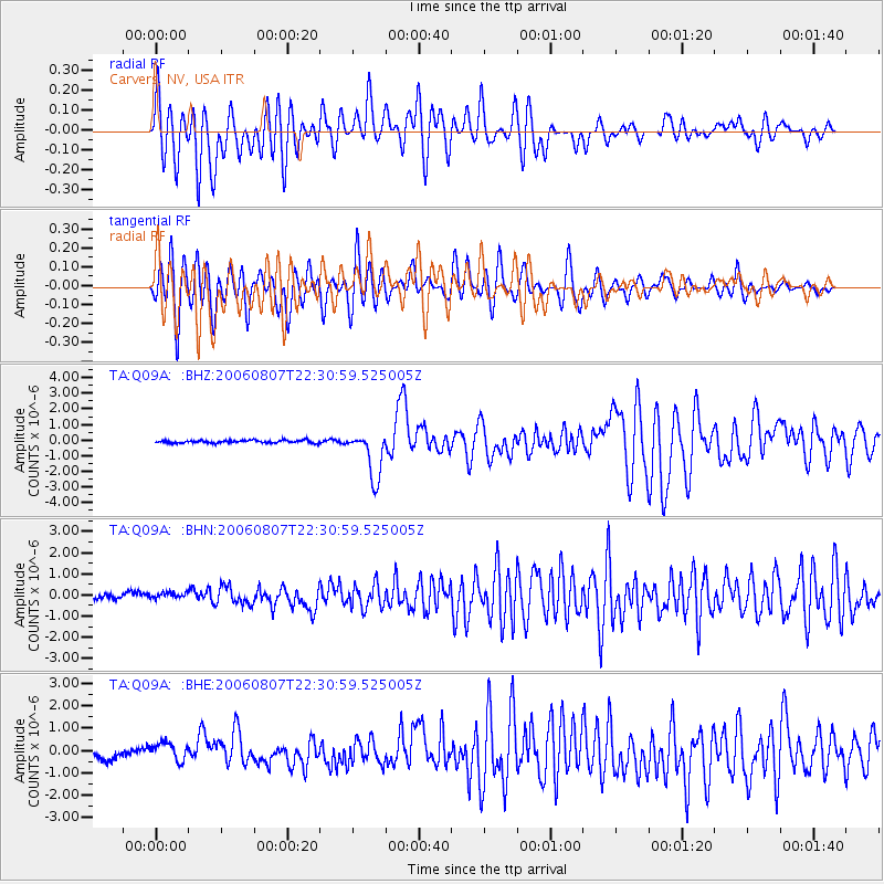
Signal To Noise
| Channel | StoN | STA | LTA |
| TA:Q09A: :BHN:20060807T22:30:59.525005Z | 1.1719561 | 2.5522013E-7 | 2.1777278E-7 |
| TA:Q09A: :BHE:20060807T22:30:59.525005Z | 2.3755178 | 4.429976E-7 | 1.8648464E-7 |
| TA:Q09A: :BHZ:20060807T22:30:59.525005Z | 16.842907 | 1.5188849E-6 | 9.01795E-8 |
| Arrivals |
| Ps | 12 SECOND |
| PpPs | 33 SECOND |
| PsPs/PpSs | 44 SECOND |


