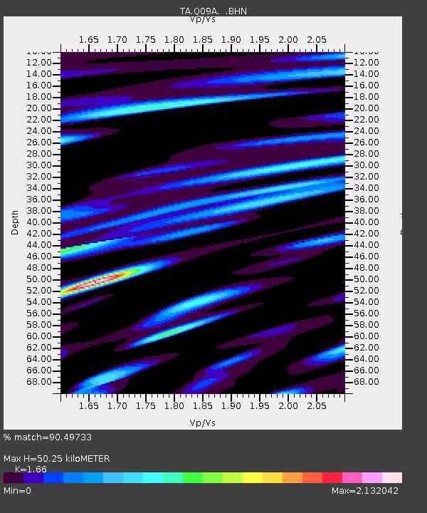
Q09A Carvers, NV, USA - Earthquake Result Viewer
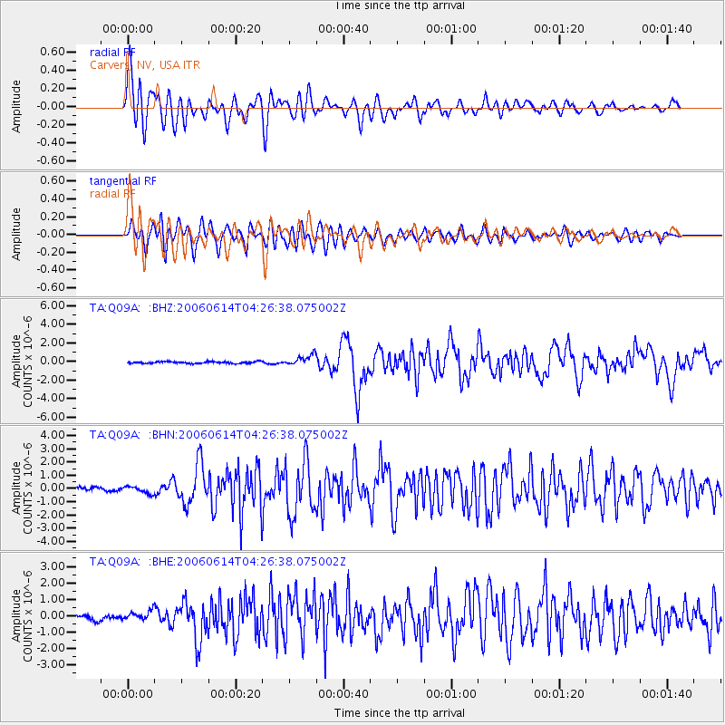
Earthquake location: Rat Islands, Aleutian Islands
Earthquake latitude/longitude: 51.8/177.1
Earthquake time(UTC): 2006/06/14 (165) 04:18:42 GMT
Earthquake Depth: 14 km
Earthquake Magnitude: 5.9 MB, 6.4 MS, 6.4 MW, 6.4 MW
Earthquake Catalog/Contributor: WHDF/NEIC
Network: TA USArray Transportable Network (new EarthScope stations)
Station: Q09A Carvers, NV, USA
Lat/Lon: 38.83 N/117.18 W
Elevation: 1704 m
Distance: 46.5 deg
Az: 79.124 deg
Baz: 308.59 deg
Ray Param: 0.070612445
Estimated Moho Depth: 50.25 km
Estimated Crust Vp/Vs: 1.66
Assumed Crust Vp: 6.276 km/s
Estimated Crust Vs: 3.781 km/s
Estimated Crust Poisson's Ratio: 0.22
Radial Match: 90.49733 %
Radial Bump: 400
Transverse Match: 86.756004 %
Transverse Bump: 400
SOD ConfigId: 5745
Insert Time: 2010-03-07 03:28:28.450 +0000
GWidth: 2.5
Max Bumps: 400
Tol: 0.001

Signal To Noise

ChannelStoNSTALTA
TA:Q09A: :BHN:20060614T04:26:38.075002Z1.49836772.6342263E-71.7580639E-7
TA:Q09A: :BHE:20060614T04:26:38.075002Z1.06338542.4527887E-72.3065849E-7
TA:Q09A: :BHZ:20060614T04:26:38.075002Z5.9760685.7851014E-79.680447E-8
Arrivals
Ps5.6 SECOND
PpPs20 SECOND
PsPs/PpSs26 SECOND