You are here: Home > Network List > US - United States National Seismic Network Stations List
> Station ERPA Erie, Pennsylvania, USA > Earthquake Result Viewer
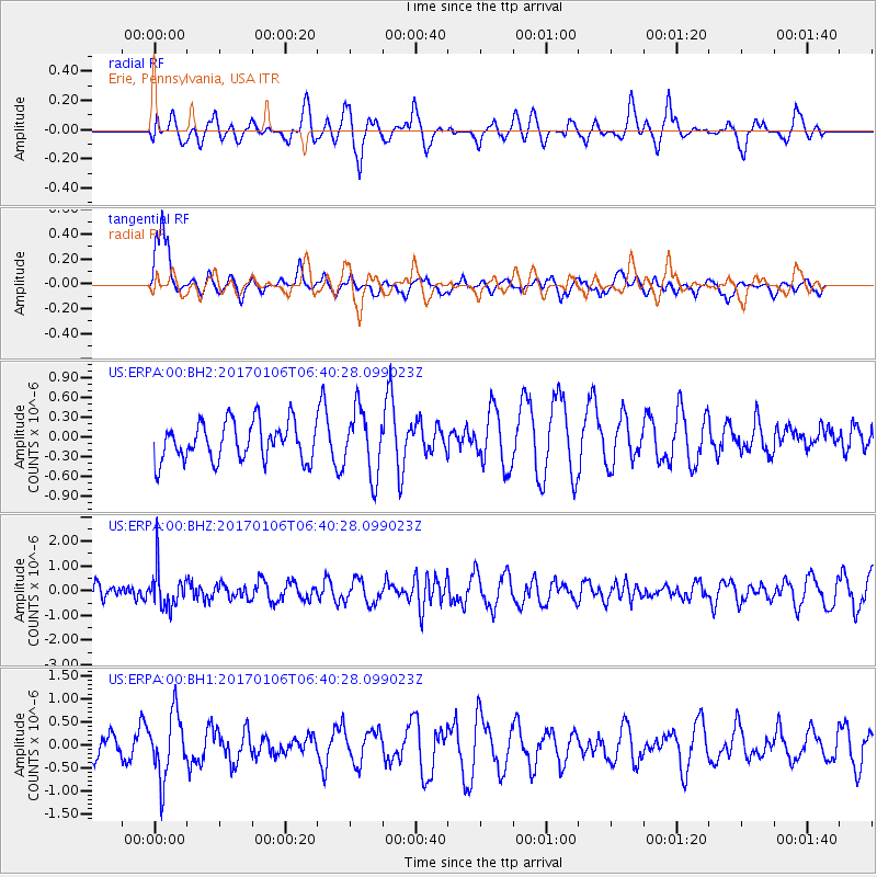
ERPA Erie, Pennsylvania, USA - Earthquake Result Viewer
*The percent match for this event was below the threshold and hence no stack was calculated.
| Earthquake location: |
Chile-Bolivia Border Region |
| Earthquake latitude/longitude: |
-22.4/-67.7 |
| Earthquake time(UTC): |
2017/01/06 (006) 06:30:33 GMT |
| Earthquake Depth: |
142 km |
| Earthquake Magnitude: |
5.7 mb |
| Earthquake Catalog/Contributor: |
NEIC PDE/us |
|
| Network: |
US United States National Seismic Network |
| Station: |
ERPA Erie, Pennsylvania, USA |
| Lat/Lon: |
42.12 N/79.99 W |
| Elevation: |
306 m |
|
| Distance: |
65.2 deg |
| Az: |
349.933 deg |
| Baz: |
167.439 deg |
| Ray Param: |
$rayparam |
*The percent match for this event was below the threshold and hence was not used in the summary stack. |
|
| Radial Match: |
54.06143 % |
| Radial Bump: |
400 |
| Transverse Match: |
68.276054 % |
| Transverse Bump: |
400 |
| SOD ConfigId: |
1943534 |
| Insert Time: |
2017-01-20 06:35:46.106 +0000 |
| GWidth: |
2.5 |
| Max Bumps: |
400 |
| Tol: |
0.001 |
|
Signal To Noise
| Channel | StoN | STA | LTA |
| US:ERPA:00:BHZ:20170106T06:40:28.099023Z | 2.630814 | 7.8869897E-7 | 2.9979276E-7 |
| US:ERPA:00:BH1:20170106T06:40:28.099023Z | 2.0646446 | 6.8948077E-7 | 3.3394645E-7 |
| US:ERPA:00:BH2:20170106T06:40:28.099023Z | 1.7020413 | 4.9423494E-7 | 2.9037776E-7 |
| Arrivals |
| Ps | |
| PpPs | |
| PsPs/PpSs | |


