You are here: Home > Network List > TA - USArray Transportable Network (new EarthScope stations) Stations List
> Station T14A Hurricane, UT, USA > Earthquake Result Viewer
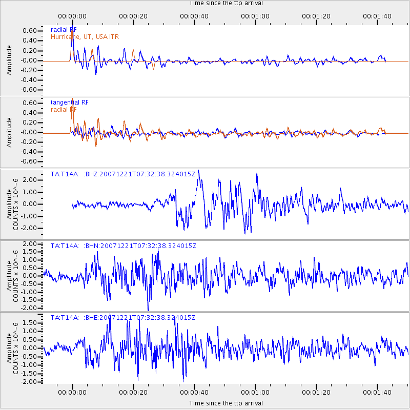
T14A Hurricane, UT, USA - Earthquake Result Viewer

| Earthquake location: |
Andreanof Islands, Aleutian Is. |
| Earthquake latitude/longitude: |
51.4/-179.0 |
| Earthquake time(UTC): |
2007/12/21 (355) 07:24:34 GMT |
| Earthquake Depth: |
30 km |
| Earthquake Magnitude: |
6.1 MB, 6.2 MW, 6.3 ML |
| Earthquake Catalog/Contributor: |
WHDF/NEIC |
|
| Network: |
TA USArray Transportable Network (new EarthScope stations) |
| Station: |
T14A Hurricane, UT, USA |
| Lat/Lon: |
37.06 N/113.08 W |
| Elevation: |
1529 m |
|
| Distance: |
47.8 deg |
| Az: |
80.536 deg |
| Baz: |
309.363 deg |
| Ray Param: |
0.06973723 |
| Estimated Moho Depth: |
15.25 km |
| Estimated Crust Vp/Vs: |
1.66 |
| Assumed Crust Vp: |
6.194 km/s |
| Estimated Crust Vs: |
3.737 km/s |
| Estimated Crust Poisson's Ratio: |
0.21 |
|
| Radial Match: |
84.79748 % |
| Radial Bump: |
400 |
| Transverse Match: |
76.62522 % |
| Transverse Bump: |
400 |
| SOD ConfigId: |
2564 |
| Insert Time: |
2010-03-07 03:30:05.826 +0000 |
| GWidth: |
2.5 |
| Max Bumps: |
400 |
| Tol: |
0.001 |
|
Signal To Noise
| Channel | StoN | STA | LTA |
| TA:T14A: :BHN:20071221T07:32:38.324015Z | 1.4566617 | 2.8870673E-7 | 1.9819751E-7 |
| TA:T14A: :BHE:20071221T07:32:38.324015Z | 1.6245533 | 4.0091928E-7 | 2.4678738E-7 |
| TA:T14A: :BHZ:20071221T07:32:38.324015Z | 5.4581923 | 6.996568E-7 | 1.2818471E-7 |
| Arrivals |
| Ps | 1.7 SECOND |
| PpPs | 6.2 SECOND |
| PsPs/PpSs | 7.9 SECOND |


