You are here: Home > Network List > TA - USArray Transportable Network (new EarthScope stations) Stations List
> Station H17K Granite Mountain, AK, USA > Earthquake Result Viewer
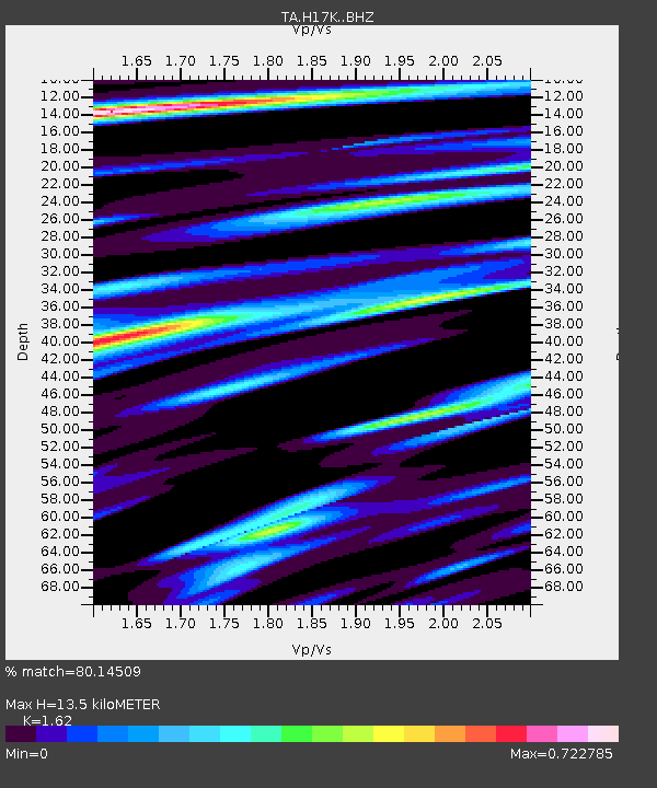
H17K Granite Mountain, AK, USA - Earthquake Result Viewer
| Earthquake location: |
Fiji Islands Region |
| Earthquake latitude/longitude: |
-14.8/-177.3 |
| Earthquake time(UTC): |
2019/08/22 (234) 19:27:12 GMT |
| Earthquake Depth: |
10 km |
| Earthquake Magnitude: |
5.8 Mww |
| Earthquake Catalog/Contributor: |
NEIC PDE/us |
|
| Network: |
TA USArray Transportable Network (new EarthScope stations) |
| Station: |
H17K Granite Mountain, AK, USA |
| Lat/Lon: |
64.94 N/159.91 W |
| Elevation: |
396 m |
|
| Distance: |
80.6 deg |
| Az: |
7.411 deg |
| Baz: |
197.032 deg |
| Ray Param: |
0.04817888 |
| Estimated Moho Depth: |
13.5 km |
| Estimated Crust Vp/Vs: |
1.62 |
| Assumed Crust Vp: |
6.1 km/s |
| Estimated Crust Vs: |
3.765 km/s |
| Estimated Crust Poisson's Ratio: |
0.19 |
|
| Radial Match: |
80.14509 % |
| Radial Bump: |
400 |
| Transverse Match: |
67.88959 % |
| Transverse Bump: |
400 |
| SOD ConfigId: |
19053131 |
| Insert Time: |
2019-09-05 19:35:56.629 +0000 |
| GWidth: |
2.5 |
| Max Bumps: |
400 |
| Tol: |
0.001 |
|

Signal To Noise
| Channel | StoN | STA | LTA |
| TA:H17K: :BHZ:20190822T19:38:53.349991Z | 3.0672946 | 1.7892798E-7 | 5.8334134E-8 |
| TA:H17K: :BHN:20190822T19:38:53.349991Z | 1.6769009 | 1.0137387E-7 | 6.045311E-8 |
| TA:H17K: :BHE:20190822T19:38:53.349991Z | 1.0819222 | 9.435065E-8 | 8.720651E-8 |
| Arrivals |
| Ps | 1.4 SECOND |
| PpPs | 5.6 SECOND |
| PsPs/PpSs | 7.1 SECOND |


