You are here: Home > Network List > TA - USArray Transportable Network (new EarthScope stations) Stations List
> Station T14A Hurricane, UT, USA > Earthquake Result Viewer
T14A Hurricane, UT, USA - Earthquake Result Viewer

| Earthquake location: |
South Of Mariana Islands |
| Earthquake latitude/longitude: |
10.5/145.7 |
| Earthquake time(UTC): |
2007/09/30 (273) 02:08:30 GMT |
| Earthquake Depth: |
14 km |
| Earthquake Magnitude: |
6.4 MB, 7.1 MS, 6.9 MW, 6.9 MW |
| Earthquake Catalog/Contributor: |
WHDF/NEIC |
|
| Network: |
TA USArray Transportable Network (new EarthScope stations) |
| Station: |
T14A Hurricane, UT, USA |
| Lat/Lon: |
37.06 N/113.08 W |
| Elevation: |
1529 m |
|
| Distance: |
92.6 deg |
| Az: |
51.765 deg |
| Baz: |
285.016 deg |
| Ray Param: |
0.041433077 |
| Estimated Moho Depth: |
14.5 km |
| Estimated Crust Vp/Vs: |
1.79 |
| Assumed Crust Vp: |
6.194 km/s |
| Estimated Crust Vs: |
3.46 km/s |
| Estimated Crust Poisson's Ratio: |
0.27 |
|
| Radial Match: |
92.58232 % |
| Radial Bump: |
400 |
| Transverse Match: |
83.93285 % |
| Transverse Bump: |
400 |
| SOD ConfigId: |
2564 |
| Insert Time: |
2010-03-07 03:30:25.700 +0000 |
| GWidth: |
2.5 |
| Max Bumps: |
400 |
| Tol: |
0.001 |
|
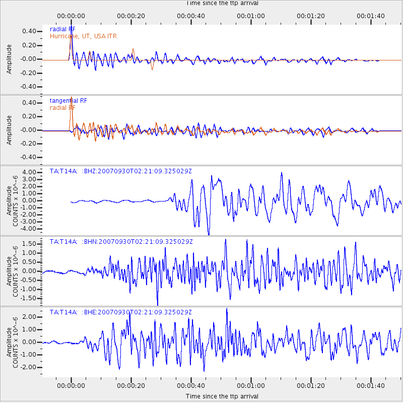
Signal To Noise
| Channel | StoN | STA | LTA |
| TA:T14A: :BHN:20070930T02:21:09.325029Z | 1.4006311 | 8.458723E-8 | 6.0392225E-8 |
| TA:T14A: :BHE:20070930T02:21:09.325029Z | 1.5652603 | 1.445415E-7 | 9.234343E-8 |
| TA:T14A: :BHZ:20070930T02:21:09.325029Z | 3.3281436 | 3.6365597E-7 | 1.0926691E-7 |
| Arrivals |
| Ps | 1.9 SECOND |
| PpPs | 6.4 SECOND |
| PsPs/PpSs | 8.3 SECOND |


