You are here: Home > Network List > TS - TERRAscope (Southern California Seismic Network) Stations List
> Station MLAC Mammoth Lakes, California, USA > Earthquake Result Viewer
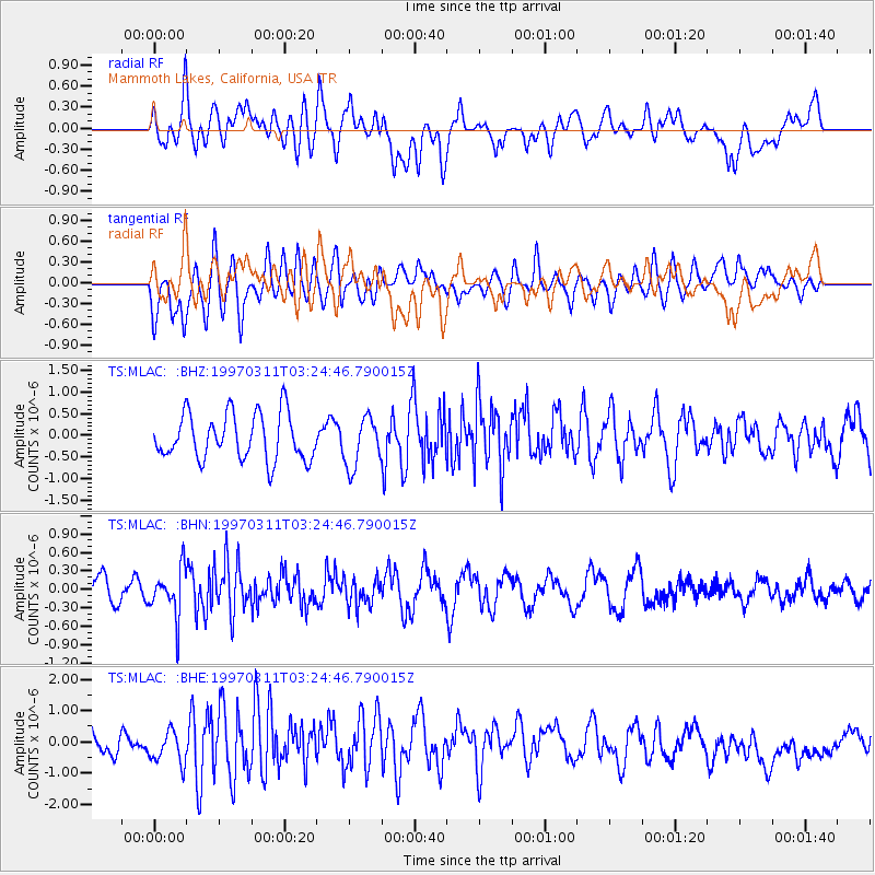
MLAC Mammoth Lakes, California, USA - Earthquake Result Viewer
*The percent match for this event was below the threshold and hence no stack was calculated.
| Earthquake location: |
Fiji Islands Region |
| Earthquake latitude/longitude: |
-21.1/-178.9 |
| Earthquake time(UTC): |
1997/03/11 (070) 03:13:59 GMT |
| Earthquake Depth: |
553 km |
| Earthquake Magnitude: |
5.7 UNKNOWN, 5.2 MB |
| Earthquake Catalog/Contributor: |
WHDF/NEIC |
|
| Network: |
TS TERRAscope (Southern California Seismic Network) |
| Station: |
MLAC Mammoth Lakes, California, USA |
| Lat/Lon: |
37.63 N/118.83 W |
| Elevation: |
2170 m |
|
| Distance: |
81.2 deg |
| Az: |
44.098 deg |
| Baz: |
234.911 deg |
| Ray Param: |
$rayparam |
*The percent match for this event was below the threshold and hence was not used in the summary stack. |
|
| Radial Match: |
53.385323 % |
| Radial Bump: |
400 |
| Transverse Match: |
46.890305 % |
| Transverse Bump: |
400 |
| SOD ConfigId: |
4480 |
| Insert Time: |
2010-02-26 14:26:30.278 +0000 |
| GWidth: |
2.5 |
| Max Bumps: |
400 |
| Tol: |
0.001 |
|
Signal To Noise
| Channel | StoN | STA | LTA |
| TS:MLAC: :BHN:19970311T03:24:46.790015Z | 2.0569983 | 3.8378263E-7 | 1.8657411E-7 |
| TS:MLAC: :BHE:19970311T03:24:46.790015Z | 1.042521 | 5.2936235E-7 | 5.077714E-7 |
| TS:MLAC: :BHZ:19970311T03:24:46.790015Z | 1.0774904 | 5.728248E-7 | 5.316286E-7 |
| Arrivals |
| Ps | |
| PpPs | |
| PsPs/PpSs | |


