You are here: Home > Network List > TA - USArray Transportable Network (new EarthScope stations) Stations List
> Station J25K Salcha River, AK, USA > Earthquake Result Viewer
J25K Salcha River, AK, USA - Earthquake Result Viewer

| Earthquake location: |
Fiji Islands Region |
| Earthquake latitude/longitude: |
-14.8/-177.3 |
| Earthquake time(UTC): |
2019/08/22 (234) 19:27:12 GMT |
| Earthquake Depth: |
10 km |
| Earthquake Magnitude: |
5.8 Mww |
| Earthquake Catalog/Contributor: |
NEIC PDE/us |
|
| Network: |
TA USArray Transportable Network (new EarthScope stations) |
| Station: |
J25K Salcha River, AK, USA |
| Lat/Lon: |
64.61 N/145.37 W |
| Elevation: |
949 m |
|
| Distance: |
82.8 deg |
| Az: |
13.283 deg |
| Baz: |
211.033 deg |
| Ray Param: |
0.046621583 |
| Estimated Moho Depth: |
28.0 km |
| Estimated Crust Vp/Vs: |
1.88 |
| Assumed Crust Vp: |
6.566 km/s |
| Estimated Crust Vs: |
3.493 km/s |
| Estimated Crust Poisson's Ratio: |
0.30 |
|
| Radial Match: |
87.12021 % |
| Radial Bump: |
359 |
| Transverse Match: |
85.79612 % |
| Transverse Bump: |
351 |
| SOD ConfigId: |
19053131 |
| Insert Time: |
2019-09-05 19:36:12.533 +0000 |
| GWidth: |
2.5 |
| Max Bumps: |
400 |
| Tol: |
0.001 |
|
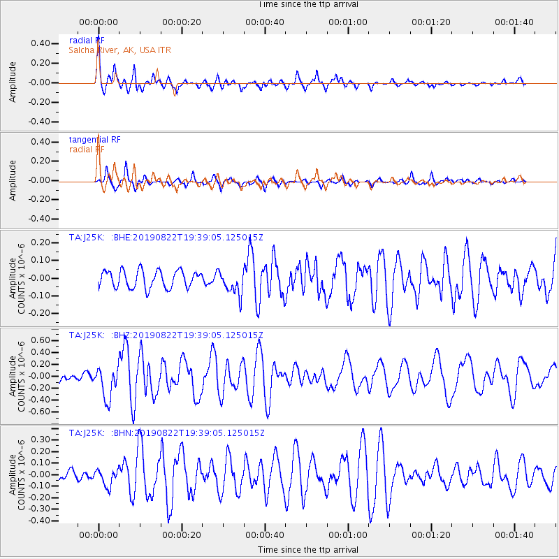
Signal To Noise
| Channel | StoN | STA | LTA |
| TA:J25K: :BHZ:20190822T19:39:05.125015Z | 3.5497591 | 2.7351516E-7 | 7.7051745E-8 |
| TA:J25K: :BHN:20190822T19:39:05.125015Z | 1.3636957 | 7.3885104E-8 | 5.418005E-8 |
| TA:J25K: :BHE:20190822T19:39:05.125015Z | 1.4332012 | 7.022347E-8 | 4.899764E-8 |
| Arrivals |
| Ps | 3.9 SECOND |
| PpPs | 12 SECOND |
| PsPs/PpSs | 16 SECOND |


