You are here: Home > Network List > TA - USArray Transportable Network (new EarthScope stations) Stations List
> Station J26L Joseph Creek, AK, USA > Earthquake Result Viewer
J26L Joseph Creek, AK, USA - Earthquake Result Viewer
| Earthquake location: |
Fiji Islands Region |
| Earthquake latitude/longitude: |
-14.8/-177.3 |
| Earthquake time(UTC): |
2019/08/22 (234) 19:27:12 GMT |
| Earthquake Depth: |
10 km |
| Earthquake Magnitude: |
5.8 Mww |
| Earthquake Catalog/Contributor: |
NEIC PDE/us |
|
| Network: |
TA USArray Transportable Network (new EarthScope stations) |
| Station: |
J26L Joseph Creek, AK, USA |
| Lat/Lon: |
64.50 N/143.56 W |
| Elevation: |
1144 m |
|
| Distance: |
83.1 deg |
| Az: |
14.01 deg |
| Baz: |
212.751 deg |
| Ray Param: |
0.046401303 |
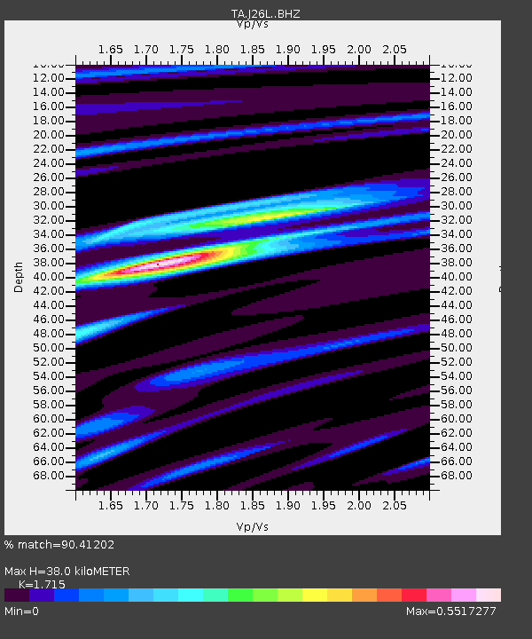
| Estimated Moho Depth: |
38.0 km |
| Estimated Crust Vp/Vs: |
1.72 |
| Assumed Crust Vp: |
6.566 km/s |
| Estimated Crust Vs: |
3.829 km/s |
| Estimated Crust Poisson's Ratio: |
0.24 |
|
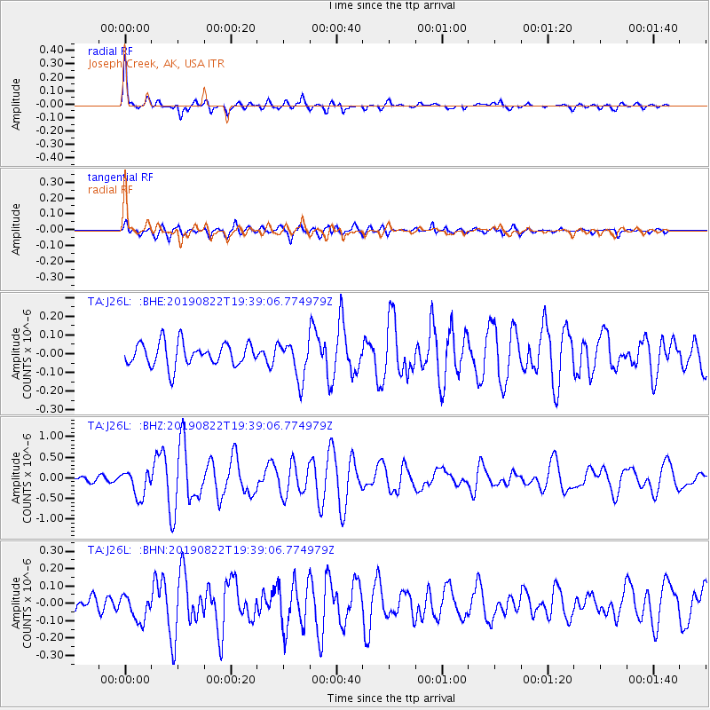
| Radial Match: |
90.41202 % |
| Radial Bump: |
348 |
| Transverse Match: |
78.86977 % |
| Transverse Bump: |
400 |
| SOD ConfigId: |
19053131 |
| Insert Time: |
2019-09-05 19:36:12.938 +0000 |
| GWidth: |
2.5 |
| Max Bumps: |
400 |
| Tol: |
0.001 |
|
Signal To Noise
| Channel | StoN | STA | LTA |
| TA:J26L: :BHZ:20190822T19:39:06.774979Z | 6.649784 | 3.2240652E-7 | 4.848376E-8 |
| TA:J26L: :BHN:20190822T19:39:06.774979Z | 1.4992933 | 7.404314E-8 | 4.9385363E-8 |
| TA:J26L: :BHE:20190822T19:39:06.774979Z | 1.641927 | 1.0069839E-7 | 6.1329395E-8 |
| Arrivals |
| Ps | 4.3 SECOND |
| PpPs | 15 SECOND |
| PsPs/PpSs | 20 SECOND |


