You are here: Home > Network List > TA - USArray Transportable Network (new EarthScope stations) Stations List
> Station L14K Kuka Creek, AK, USA > Earthquake Result Viewer
L14K Kuka Creek, AK, USA - Earthquake Result Viewer
| Earthquake location: |
Fiji Islands Region |
| Earthquake latitude/longitude: |
-14.8/-177.3 |
| Earthquake time(UTC): |
2019/08/22 (234) 19:27:12 GMT |
| Earthquake Depth: |
10 km |
| Earthquake Magnitude: |
5.8 Mww |
| Earthquake Catalog/Contributor: |
NEIC PDE/us |
|
| Network: |
TA USArray Transportable Network (new EarthScope stations) |
| Station: |
L14K Kuka Creek, AK, USA |
| Lat/Lon: |
61.34 N/162.68 W |
| Elevation: |
41 m |
|
| Distance: |
76.8 deg |
| Az: |
7.176 deg |
| Baz: |
194.517 deg |
| Ray Param: |
0.050773866 |
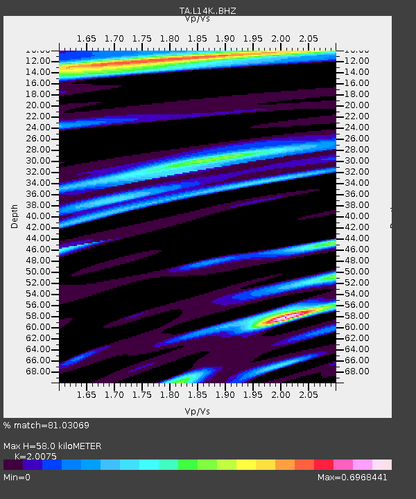
| Estimated Moho Depth: |
58.0 km |
| Estimated Crust Vp/Vs: |
2.01 |
| Assumed Crust Vp: |
6.1 km/s |
| Estimated Crust Vs: |
3.039 km/s |
| Estimated Crust Poisson's Ratio: |
0.33 |
|
| Radial Match: |
81.03069 % |
| Radial Bump: |
400 |
| Transverse Match: |
69.76349 % |
| Transverse Bump: |
400 |
| SOD ConfigId: |
19053131 |
| Insert Time: |
2019-09-05 19:36:18.192 +0000 |
| GWidth: |
2.5 |
| Max Bumps: |
400 |
| Tol: |
0.001 |
|

Signal To Noise
| Channel | StoN | STA | LTA |
| TA:L14K: :BHZ:20190822T19:38:32.425003Z | 2.4717393 | 3.0010807E-7 | 1.2141575E-7 |
| TA:L14K: :BHN:20190822T19:38:32.425003Z | 0.8927954 | 1.2046704E-7 | 1.3493242E-7 |
| TA:L14K: :BHE:20190822T19:38:32.425003Z | 0.88781136 | 1.012948E-7 | 1.1409496E-7 |
| Arrivals |
| Ps | 9.8 SECOND |
| PpPs | 28 SECOND |
| PsPs/PpSs | 38 SECOND |


