You are here: Home > Network List > TA - USArray Transportable Network (new EarthScope stations) Stations List
> Station T14A Hurricane, UT, USA > Earthquake Result Viewer
T14A Hurricane, UT, USA - Earthquake Result Viewer
| Earthquake location: |
Near West Coast Of Colombia |
| Earthquake latitude/longitude: |
3.0/-78.0 |
| Earthquake time(UTC): |
2007/09/10 (253) 01:49:14 GMT |
| Earthquake Depth: |
31 km |
| Earthquake Magnitude: |
6.1 MB, 6.7 MS, 6.8 MW |
| Earthquake Catalog/Contributor: |
WHDF/NEIC |
|
| Network: |
TA USArray Transportable Network (new EarthScope stations) |
| Station: |
T14A Hurricane, UT, USA |
| Lat/Lon: |
37.06 N/113.08 W |
| Elevation: |
1529 m |
|
| Distance: |
46.8 deg |
| Az: |
320.863 deg |
| Baz: |
128.002 deg |
| Ray Param: |
0.07034925 |
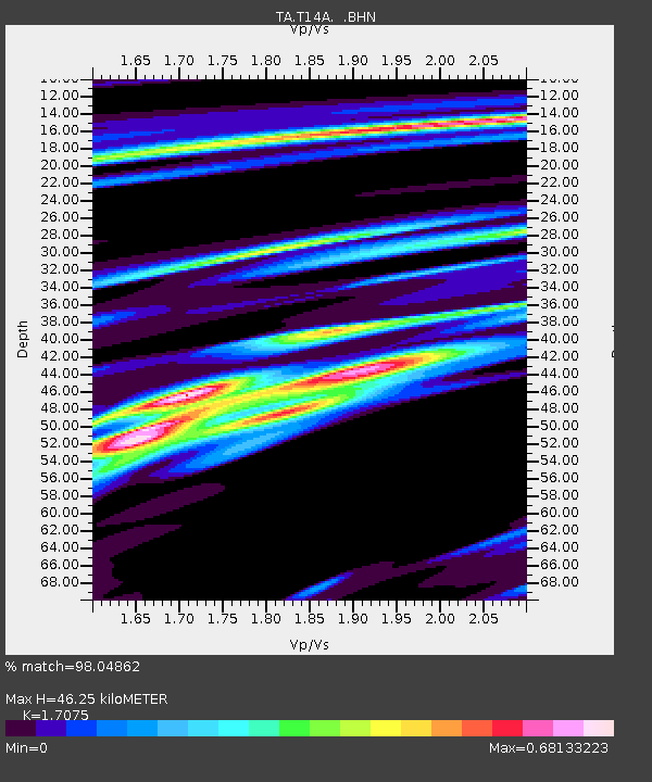
| Estimated Moho Depth: |
46.25 km |
| Estimated Crust Vp/Vs: |
1.71 |
| Assumed Crust Vp: |
6.194 km/s |
| Estimated Crust Vs: |
3.628 km/s |
| Estimated Crust Poisson's Ratio: |
0.24 |
|
| Radial Match: |
98.04862 % |
| Radial Bump: |
386 |
| Transverse Match: |
84.550125 % |
| Transverse Bump: |
400 |
| SOD ConfigId: |
2564 |
| Insert Time: |
2010-03-07 03:30:30.083 +0000 |
| GWidth: |
2.5 |
| Max Bumps: |
400 |
| Tol: |
0.001 |
|

Signal To Noise
| Channel | StoN | STA | LTA |
| TA:T14A: :BHN:20070910T01:57:10.350005Z | 2.8459759 | 5.447086E-7 | 1.9139608E-7 |
| TA:T14A: :BHE:20070910T01:57:10.350005Z | 5.373825 | 5.987417E-7 | 1.1141816E-7 |
| TA:T14A: :BHZ:20070910T01:57:10.350005Z | 7.219567 | 1.515446E-6 | 2.0990817E-7 |
| Arrivals |
| Ps | 5.6 SECOND |
| PpPs | 19 SECOND |
| PsPs/PpSs | 25 SECOND |


