You are here: Home > Network List > TA - USArray Transportable Network (new EarthScope stations) Stations List
> Station O18K Koktuh Hills, AK, USA > Earthquake Result Viewer
O18K Koktuh Hills, AK, USA - Earthquake Result Viewer
| Earthquake location: |
Fiji Islands Region |
| Earthquake latitude/longitude: |
-14.8/-177.3 |
| Earthquake time(UTC): |
2019/08/22 (234) 19:27:12 GMT |
| Earthquake Depth: |
10 km |
| Earthquake Magnitude: |
5.8 Mww |
| Earthquake Catalog/Contributor: |
NEIC PDE/us |
|
| Network: |
TA USArray Transportable Network (new EarthScope stations) |
| Station: |
O18K Koktuh Hills, AK, USA |
| Lat/Lon: |
59.85 N/155.21 W |
| Elevation: |
544 m |
|
| Distance: |
76.5 deg |
| Az: |
11.254 deg |
| Baz: |
201.964 deg |
| Ray Param: |
0.050949197 |
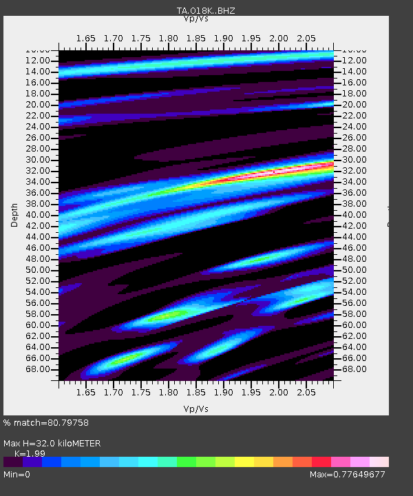
| Estimated Moho Depth: |
32.0 km |
| Estimated Crust Vp/Vs: |
1.99 |
| Assumed Crust Vp: |
6.438 km/s |
| Estimated Crust Vs: |
3.235 km/s |
| Estimated Crust Poisson's Ratio: |
0.33 |
|
| Radial Match: |
80.79758 % |
| Radial Bump: |
394 |
| Transverse Match: |
56.725056 % |
| Transverse Bump: |
400 |
| SOD ConfigId: |
19053131 |
| Insert Time: |
2019-09-05 19:36:35.804 +0000 |
| GWidth: |
2.5 |
| Max Bumps: |
400 |
| Tol: |
0.001 |
|

Signal To Noise
| Channel | StoN | STA | LTA |
| TA:O18K: :BHZ:20190822T19:38:30.950027Z | 2.872683 | 3.6490874E-7 | 1.2702715E-7 |
| TA:O18K: :BHN:20190822T19:38:30.950027Z | 2.0379047 | 2.8634156E-7 | 1.4050782E-7 |
| TA:O18K: :BHE:20190822T19:38:30.950027Z | 0.7827992 | 1.2697441E-7 | 1.6220561E-7 |
| Arrivals |
| Ps | 5.1 SECOND |
| PpPs | 14 SECOND |
| PsPs/PpSs | 20 SECOND |


