You are here: Home > Network List > TA - USArray Transportable Network (new EarthScope stations) Stations List
> Station R33M Jennings River, BC, CAN > Earthquake Result Viewer
R33M Jennings River, BC, CAN - Earthquake Result Viewer
| Earthquake location: |
Fiji Islands Region |
| Earthquake latitude/longitude: |
-14.8/-177.3 |
| Earthquake time(UTC): |
2019/08/22 (234) 19:27:12 GMT |
| Earthquake Depth: |
10 km |
| Earthquake Magnitude: |
5.8 Mww |
| Earthquake Catalog/Contributor: |
NEIC PDE/us |
|
| Network: |
TA USArray Transportable Network (new EarthScope stations) |
| Station: |
R33M Jennings River, BC, CAN |
| Lat/Lon: |
59.39 N/130.97 W |
| Elevation: |
1437 m |
|
| Distance: |
82.9 deg |
| Az: |
21.897 deg |
| Baz: |
224.833 deg |
| Ray Param: |
0.046573125 |
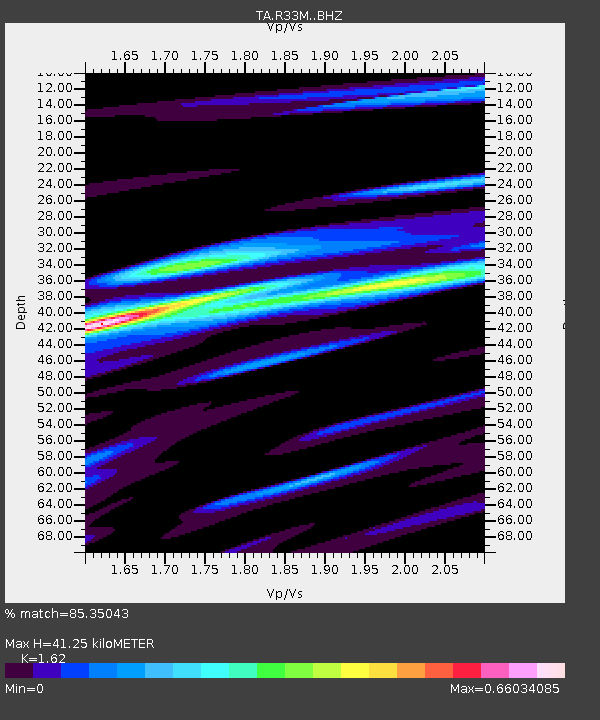
| Estimated Moho Depth: |
41.25 km |
| Estimated Crust Vp/Vs: |
1.62 |
| Assumed Crust Vp: |
6.597 km/s |
| Estimated Crust Vs: |
4.073 km/s |
| Estimated Crust Poisson's Ratio: |
0.19 |
|
| Radial Match: |
85.35043 % |
| Radial Bump: |
400 |
| Transverse Match: |
66.34466 % |
| Transverse Bump: |
400 |
| SOD ConfigId: |
19053131 |
| Insert Time: |
2019-09-05 19:36:45.041 +0000 |
| GWidth: |
2.5 |
| Max Bumps: |
400 |
| Tol: |
0.001 |
|
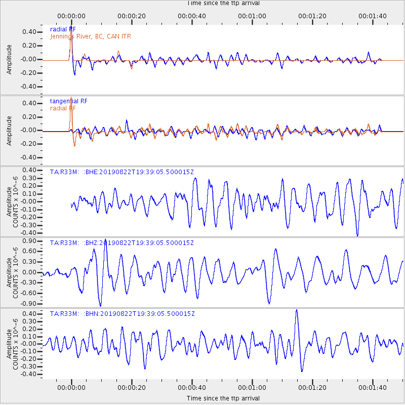
Signal To Noise
| Channel | StoN | STA | LTA |
| TA:R33M: :BHZ:20190822T19:39:05.500015Z | 6.736373 | 2.7566045E-7 | 4.0921197E-8 |
| TA:R33M: :BHN:20190822T19:39:05.500015Z | 1.3039235 | 8.203894E-8 | 6.291699E-8 |
| TA:R33M: :BHE:20190822T19:39:05.500015Z | 1.6609477 | 1.1537301E-7 | 6.946216E-8 |
| Arrivals |
| Ps | 4.0 SECOND |
| PpPs | 16 SECOND |
| PsPs/PpSs | 20 SECOND |


