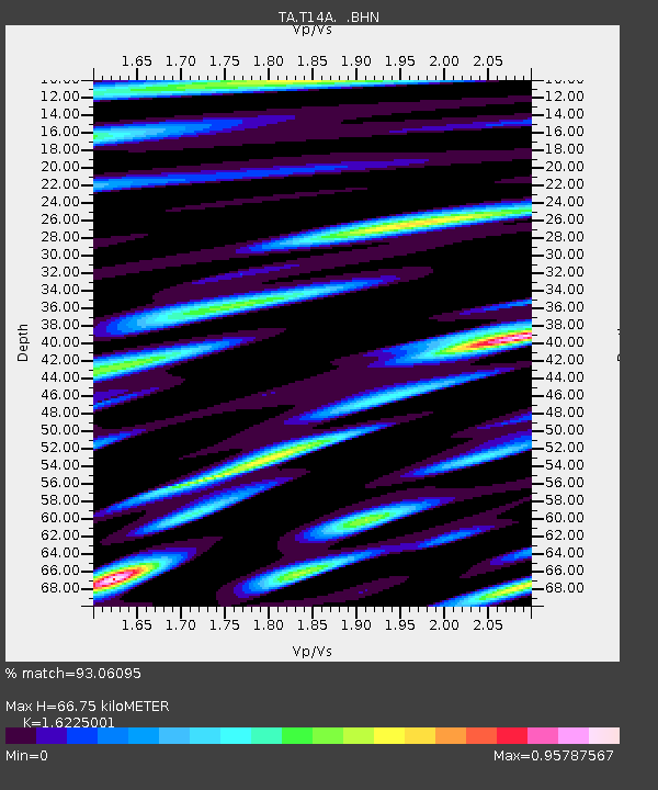
T14A Hurricane, UT, USA - Earthquake Result Viewer

Earthquake location: Near West Coast Of Honshu, Japan
Earthquake latitude/longitude: 37.5/138.4
Earthquake time(UTC): 2007/07/16 (197) 01:13:22 GMT
Earthquake Depth: 12 km
Earthquake Magnitude: 6.5 MB, 6.4 MS, 6.6 MW, 6.5 MW
Earthquake Catalog/Contributor: WHDF/NEIC
Network: TA USArray Transportable Network (new EarthScope stations)
Station: T14A Hurricane, UT, USA
Lat/Lon: 37.06 N/113.08 W
Elevation: 1529 m
Distance: 80.6 deg
Az: 50.26 deg
Baz: 310.166 deg
Ray Param: 0.048134055
Estimated Moho Depth: 66.75 km
Estimated Crust Vp/Vs: 1.62
Assumed Crust Vp: 6.194 km/s
Estimated Crust Vs: 3.818 km/s
Estimated Crust Poisson's Ratio: 0.19
Radial Match: 93.06095 %
Radial Bump: 400
Transverse Match: 85.2605 %
Transverse Bump: 400
SOD ConfigId: 2564
Insert Time: 2010-03-07 03:30:56.214 +0000
GWidth: 2.5
Max Bumps: 400
Tol: 0.001

Signal To Noise

ChannelStoNSTALTA
TA:T14A: :BHN:20070716T01:25:03.500005Z9.5839035.043906E-75.2628927E-8
TA:T14A: :BHE:20070716T01:25:03.500005Z14.7475126.223049E-74.2197282E-8
TA:T14A: :BHZ:20070716T01:25:03.500005Z41.4746062.0178913E-64.8653657E-8
Arrivals
Ps6.9 SECOND
PpPs27 SECOND
PsPs/PpSs34 SECOND