You are here: Home > Network List > TA - USArray Transportable Network (new EarthScope stations) Stations List
> Station T14A Hurricane, UT, USA > Earthquake Result Viewer
T14A Hurricane, UT, USA - Earthquake Result Viewer

| Earthquake location: |
Vanuatu Islands |
| Earthquake latitude/longitude: |
-15.4/168.6 |
| Earthquake time(UTC): |
2007/07/15 (196) 09:27:34 GMT |
| Earthquake Depth: |
8.0 km |
| Earthquake Magnitude: |
6.0 MB, 5.8 MS, 6.1 MW, 6.0 MW |
| Earthquake Catalog/Contributor: |
WHDF/NEIC |
|
| Network: |
TA USArray Transportable Network (new EarthScope stations) |
| Station: |
T14A Hurricane, UT, USA |
| Lat/Lon: |
37.06 N/113.08 W |
| Elevation: |
1529 m |
|
| Distance: |
90.1 deg |
| Az: |
51.57 deg |
| Baz: |
250.848 deg |
| Ray Param: |
0.04169689 |
| Estimated Moho Depth: |
47.5 km |
| Estimated Crust Vp/Vs: |
1.60 |
| Assumed Crust Vp: |
6.194 km/s |
| Estimated Crust Vs: |
3.871 km/s |
| Estimated Crust Poisson's Ratio: |
0.18 |
|
| Radial Match: |
94.36983 % |
| Radial Bump: |
400 |
| Transverse Match: |
84.90098 % |
| Transverse Bump: |
400 |
| SOD ConfigId: |
2564 |
| Insert Time: |
2010-03-07 03:30:59.770 +0000 |
| GWidth: |
2.5 |
| Max Bumps: |
400 |
| Tol: |
0.001 |
|
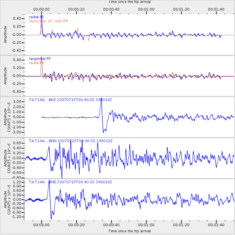
Signal To Noise
| Channel | StoN | STA | LTA |
| TA:T14A: :BHN:20070715T09:40:03.349019Z | 3.5211093 | 1.7418728E-7 | 4.946943E-8 |
| TA:T14A: :BHE:20070715T09:40:03.349019Z | 13.987179 | 4.6302793E-7 | 3.310374E-8 |
| TA:T14A: :BHZ:20070715T09:40:03.349019Z | 25.95889 | 1.3102912E-6 | 5.047562E-8 |
| Arrivals |
| Ps | 4.7 SECOND |
| PpPs | 20 SECOND |
| PsPs/PpSs | 24 SECOND |


