You are here: Home > Network List > TA - USArray Transportable Network (new EarthScope stations) Stations List
> Station T14A Hurricane, UT, USA > Earthquake Result Viewer
T14A Hurricane, UT, USA - Earthquake Result Viewer

| Earthquake location: |
Kamchatka Peninsula, Russia |
| Earthquake latitude/longitude: |
52.1/157.3 |
| Earthquake time(UTC): |
2007/05/30 (150) 20:22:12 GMT |
| Earthquake Depth: |
116 km |
| Earthquake Magnitude: |
6.4 MB, 6.4 MW, 6.4 MW |
| Earthquake Catalog/Contributor: |
WHDF/NEIC |
|
| Network: |
TA USArray Transportable Network (new EarthScope stations) |
| Station: |
T14A Hurricane, UT, USA |
| Lat/Lon: |
37.06 N/113.08 W |
| Elevation: |
1529 m |
|
| Distance: |
61.6 deg |
| Az: |
65.43 deg |
| Baz: |
315.514 deg |
| Ray Param: |
0.060451947 |
| Estimated Moho Depth: |
26.0 km |
| Estimated Crust Vp/Vs: |
1.98 |
| Assumed Crust Vp: |
6.194 km/s |
| Estimated Crust Vs: |
3.132 km/s |
| Estimated Crust Poisson's Ratio: |
0.33 |
|
| Radial Match: |
89.2373 % |
| Radial Bump: |
400 |
| Transverse Match: |
78.28548 % |
| Transverse Bump: |
400 |
| SOD ConfigId: |
2564 |
| Insert Time: |
2010-03-07 03:31:05.785 +0000 |
| GWidth: |
2.5 |
| Max Bumps: |
400 |
| Tol: |
0.001 |
|
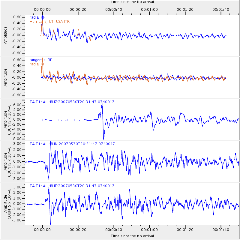
Signal To Noise
| Channel | StoN | STA | LTA |
| TA:T14A: :BHN:20070530T20:31:47.074001Z | 26.241177 | 1.453794E-6 | 5.540125E-8 |
| TA:T14A: :BHE:20070530T20:31:47.074001Z | 22.944897 | 1.4125338E-6 | 6.1562005E-8 |
| TA:T14A: :BHZ:20070530T20:31:47.074001Z | 47.5401 | 3.5683415E-6 | 7.505961E-8 |
| Arrivals |
| Ps | 4.3 SECOND |
| PpPs | 12 SECOND |
| PsPs/PpSs | 16 SECOND |


