You are here: Home > Network List > UW - Pacific Northwest Regional Seismic Network Stations List
> Station UMAT Pilot Rock, OR, USA > Earthquake Result Viewer
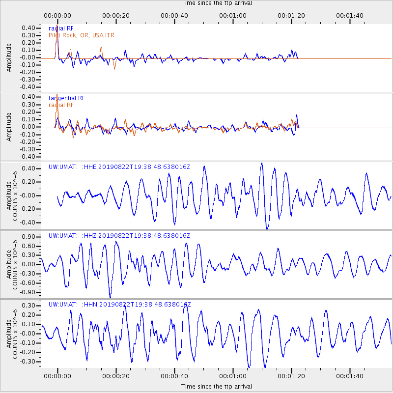
UMAT Pilot Rock, OR, USA - Earthquake Result Viewer
*The percent match for this event was below the threshold and hence no stack was calculated.
| Earthquake location: |
Fiji Islands Region |
| Earthquake latitude/longitude: |
-14.8/-177.3 |
| Earthquake time(UTC): |
2019/08/22 (234) 19:27:12 GMT |
| Earthquake Depth: |
10 km |
| Earthquake Magnitude: |
5.8 Mww |
| Earthquake Catalog/Contributor: |
NEIC PDE/us |
|
| Network: |
UW Pacific Northwest Regional Seismic Network |
| Station: |
UMAT Pilot Rock, OR, USA |
| Lat/Lon: |
45.29 N/118.96 W |
| Elevation: |
1318 m |
|
| Distance: |
79.7 deg |
| Az: |
37.636 deg |
| Baz: |
236.799 deg |
| Ray Param: |
$rayparam |
*The percent match for this event was below the threshold and hence was not used in the summary stack. |
|
| Radial Match: |
70.36563 % |
| Radial Bump: |
299 |
| Transverse Match: |
54.84298 % |
| Transverse Bump: |
400 |
| SOD ConfigId: |
19053131 |
| Insert Time: |
2019-09-05 19:38:39.182 +0000 |
| GWidth: |
2.5 |
| Max Bumps: |
400 |
| Tol: |
0.001 |
|
Signal To Noise
| Channel | StoN | STA | LTA |
| UW:UMAT: :HHZ:20190822T19:38:48.638016Z | 2.6824393 | 3.8971595E-7 | 1.4528416E-7 |
| UW:UMAT: :HHN:20190822T19:38:48.638016Z | 1.4602907 | 1.1407958E-7 | 7.812115E-8 |
| UW:UMAT: :HHE:20190822T19:38:48.638016Z | 2.3150263 | 1.9522004E-7 | 8.432735E-8 |
| Arrivals |
| Ps | |
| PpPs | |
| PsPs/PpSs | |


