You are here: Home > Network List > TA - USArray Transportable Network (new EarthScope stations) Stations List
> Station Q08A Gabbs, NV, USA > Earthquake Result Viewer
Q08A Gabbs, NV, USA - Earthquake Result Viewer
| Earthquake location: |
Near West Coast Of Colombia |
| Earthquake latitude/longitude: |
3.0/-78.0 |
| Earthquake time(UTC): |
2007/09/10 (253) 01:49:14 GMT |
| Earthquake Depth: |
31 km |
| Earthquake Magnitude: |
6.1 MB, 6.7 MS, 6.8 MW |
| Earthquake Catalog/Contributor: |
WHDF/NEIC |
|
| Network: |
TA USArray Transportable Network (new EarthScope stations) |
| Station: |
Q08A Gabbs, NV, USA |
| Lat/Lon: |
38.86 N/117.93 W |
| Elevation: |
1412 m |
|
| Distance: |
51.0 deg |
| Az: |
319.786 deg |
| Baz: |
124.323 deg |
| Ray Param: |
0.06765865 |
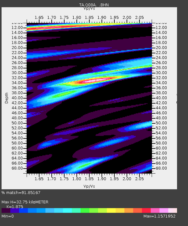
| Estimated Moho Depth: |
32.75 km |
| Estimated Crust Vp/Vs: |
1.88 |
| Assumed Crust Vp: |
6.276 km/s |
| Estimated Crust Vs: |
3.347 km/s |
| Estimated Crust Poisson's Ratio: |
0.30 |
|
| Radial Match: |
91.85167 % |
| Radial Bump: |
400 |
| Transverse Match: |
91.084335 % |
| Transverse Bump: |
400 |
| SOD ConfigId: |
2564 |
| Insert Time: |
2010-03-07 03:31:35.287 +0000 |
| GWidth: |
2.5 |
| Max Bumps: |
400 |
| Tol: |
0.001 |
|
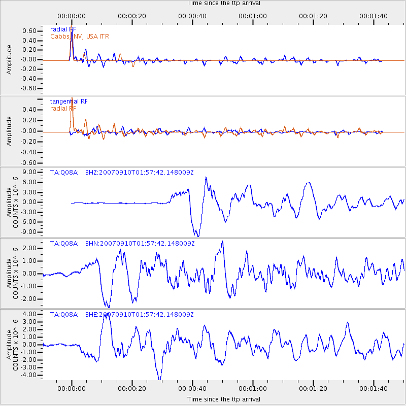
Signal To Noise
| Channel | StoN | STA | LTA |
| TA:Q08A: :BHN:20070910T01:57:42.148009Z | 3.7467146 | 3.1912833E-7 | 8.5175515E-8 |
| TA:Q08A: :BHE:20070910T01:57:42.148009Z | 5.3132153 | 6.402221E-7 | 1.2049617E-7 |
| TA:Q08A: :BHZ:20070910T01:57:42.148009Z | 21.21714 | 1.3878109E-6 | 6.54099E-8 |
| Arrivals |
| Ps | 4.8 SECOND |
| PpPs | 14 SECOND |
| PsPs/PpSs | 19 SECOND |


