You are here: Home > Network List > TA - USArray Transportable Network (new EarthScope stations) Stations List
> Station Q08A Gabbs, NV, USA > Earthquake Result Viewer
Q08A Gabbs, NV, USA - Earthquake Result Viewer
| Earthquake location: |
Solomon Islands |
| Earthquake latitude/longitude: |
-9.8/159.5 |
| Earthquake time(UTC): |
2007/08/16 (228) 08:39:27 GMT |
| Earthquake Depth: |
10 km |
| Earthquake Magnitude: |
6.1 MB, 6.7 MS, 6.4 MW |
| Earthquake Catalog/Contributor: |
WHDF/NEIC |
|
| Network: |
TA USArray Transportable Network (new EarthScope stations) |
| Station: |
Q08A Gabbs, NV, USA |
| Lat/Lon: |
38.86 N/117.93 W |
| Elevation: |
1412 m |
|
| Distance: |
90.4 deg |
| Az: |
50.737 deg |
| Baz: |
257.776 deg |
| Ray Param: |
0.04167638 |
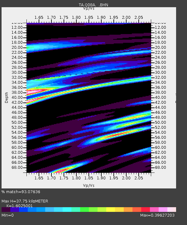
| Estimated Moho Depth: |
37.75 km |
| Estimated Crust Vp/Vs: |
1.60 |
| Assumed Crust Vp: |
6.276 km/s |
| Estimated Crust Vs: |
3.916 km/s |
| Estimated Crust Poisson's Ratio: |
0.18 |
|
| Radial Match: |
93.07636 % |
| Radial Bump: |
400 |
| Transverse Match: |
90.284706 % |
| Transverse Bump: |
400 |
| SOD ConfigId: |
2564 |
| Insert Time: |
2010-03-07 03:31:42.462 +0000 |
| GWidth: |
2.5 |
| Max Bumps: |
400 |
| Tol: |
0.001 |
|
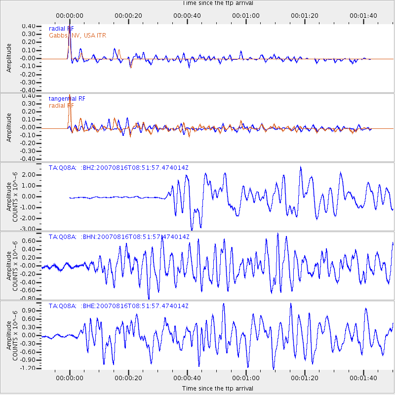
Signal To Noise
| Channel | StoN | STA | LTA |
| TA:Q08A: :BHN:20070816T08:51:57.474014Z | 1.0607756 | 3.3592904E-8 | 3.1668247E-8 |
| TA:Q08A: :BHE:20070816T08:51:57.474014Z | 3.227901 | 1.1665457E-7 | 3.613945E-8 |
| TA:Q08A: :BHZ:20070816T08:51:57.474014Z | 5.85835 | 2.479637E-7 | 4.2326544E-8 |
| Arrivals |
| Ps | 3.7 SECOND |
| PpPs | 15 SECOND |
| PsPs/PpSs | 19 SECOND |


