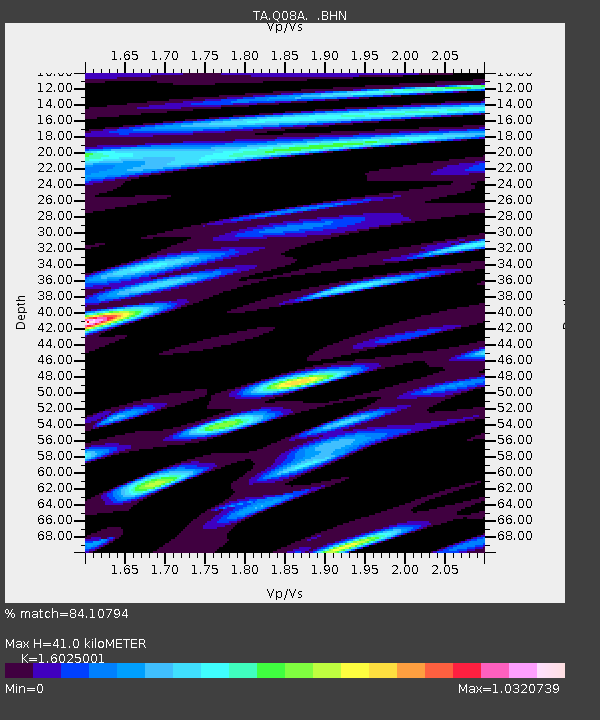
Q08A Gabbs, NV, USA - Earthquake Result Viewer
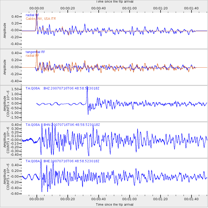
Earthquake location: Near West Coast Of Honshu, Japan
Earthquake latitude/longitude: 37.5/138.5
Earthquake time(UTC): 2007/07/16 (197) 06:37:40 GMT
Earthquake Depth: 15 km
Earthquake Magnitude: 5.7 MB, 5.1 MS, 5.7 MW, 5.6 MW
Earthquake Catalog/Contributor: WHDF/NEIC
Network: TA USArray Transportable Network (new EarthScope stations)
Station: Q08A Gabbs, NV, USA
Lat/Lon: 38.86 N/117.93 W
Elevation: 1412 m
Distance: 76.5 deg
Az: 51.285 deg
Baz: 307.36 deg
Ray Param: 0.050917026
Estimated Moho Depth: 41.0 km
Estimated Crust Vp/Vs: 1.60
Assumed Crust Vp: 6.276 km/s
Estimated Crust Vs: 3.916 km/s
Estimated Crust Poisson's Ratio: 0.18
Radial Match: 84.10794 %
Radial Bump: 400
Transverse Match: 82.008545 %
Transverse Bump: 400
SOD ConfigId: 2564
Insert Time: 2010-03-07 03:31:58.632 +0000
GWidth: 2.5
Max Bumps: 400
Tol: 0.001

Signal To Noise

ChannelStoNSTALTA
TA:Q08A: :BHN:20070716T06:48:58.523018Z3.10499431.4644932E-74.7165734E-8
TA:Q08A: :BHE:20070716T06:48:58.523018Z6.32524542.0957742E-73.3133485E-8
TA:Q08A: :BHZ:20070716T06:48:58.523018Z8.7416155.8385586E-76.6790385E-8
Arrivals
Ps4.1 SECOND
PpPs16 SECOND
PsPs/PpSs21 SECOND