You are here: Home > Network List > TA - USArray Transportable Network (new EarthScope stations) Stations List
> Station Q08A Gabbs, NV, USA > Earthquake Result Viewer
Q08A Gabbs, NV, USA - Earthquake Result Viewer
| Earthquake location: |
Near Coast Of Guatemala |
| Earthquake latitude/longitude: |
13.8/-90.8 |
| Earthquake time(UTC): |
2007/06/08 (159) 13:32:00 GMT |
| Earthquake Depth: |
48 km |
| Earthquake Magnitude: |
5.5 MB, 5.4 MS, 5.8 MW, 5.8 MW |
| Earthquake Catalog/Contributor: |
WHDF/NEIC |
|
| Network: |
TA USArray Transportable Network (new EarthScope stations) |
| Station: |
Q08A Gabbs, NV, USA |
| Lat/Lon: |
38.86 N/117.93 W |
| Elevation: |
1412 m |
|
| Distance: |
34.6 deg |
| Az: |
321.111 deg |
| Baz: |
128.637 deg |
| Ray Param: |
0.07754786 |
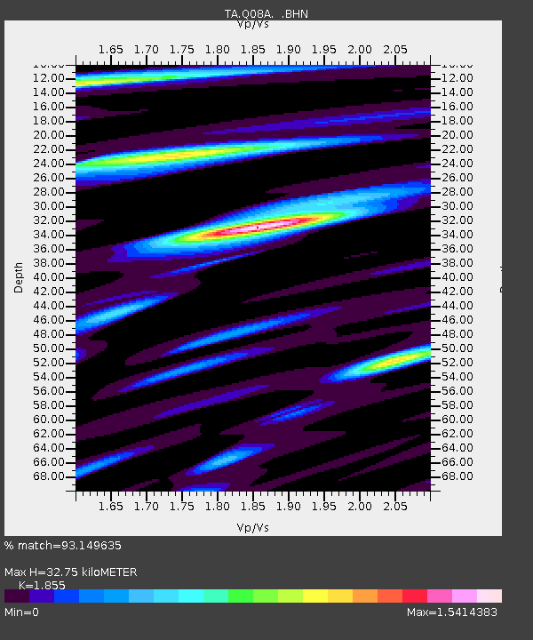
| Estimated Moho Depth: |
32.75 km |
| Estimated Crust Vp/Vs: |
1.86 |
| Assumed Crust Vp: |
6.276 km/s |
| Estimated Crust Vs: |
3.383 km/s |
| Estimated Crust Poisson's Ratio: |
0.30 |
|
| Radial Match: |
93.149635 % |
| Radial Bump: |
400 |
| Transverse Match: |
81.62727 % |
| Transverse Bump: |
400 |
| SOD ConfigId: |
2564 |
| Insert Time: |
2010-03-07 03:32:06.189 +0000 |
| GWidth: |
2.5 |
| Max Bumps: |
400 |
| Tol: |
0.001 |
|

Signal To Noise
| Channel | StoN | STA | LTA |
| TA:Q08A: :BHN:20070608T13:38:14.798015Z | 5.608952 | 2.4727603E-7 | 4.4085958E-8 |
| TA:Q08A: :BHE:20070608T13:38:14.798015Z | 8.618449 | 3.80393E-7 | 4.413706E-8 |
| TA:Q08A: :BHZ:20070608T13:38:14.798015Z | 10.57383 | 8.4825683E-7 | 8.022229E-8 |
| Arrivals |
| Ps | 4.8 SECOND |
| PpPs | 14 SECOND |
| PsPs/PpSs | 19 SECOND |


