You are here: Home > Network List > TA - USArray Transportable Network (new EarthScope stations) Stations List
> Station Q08A Gabbs, NV, USA > Earthquake Result Viewer
Q08A Gabbs, NV, USA - Earthquake Result Viewer
| Earthquake location: |
Hokkaido, Japan Region |
| Earthquake latitude/longitude: |
41.6/142.0 |
| Earthquake time(UTC): |
2007/05/18 (138) 15:59:58 GMT |
| Earthquake Depth: |
58 km |
| Earthquake Magnitude: |
5.5 MB, 5.5 MW, 5.4 MW |
| Earthquake Catalog/Contributor: |
WHDF/NEIC |
|
| Network: |
TA USArray Transportable Network (new EarthScope stations) |
| Station: |
Q08A Gabbs, NV, USA |
| Lat/Lon: |
38.86 N/117.93 W |
| Elevation: |
1412 m |
|
| Distance: |
71.9 deg |
| Az: |
53.973 deg |
| Baz: |
309.017 deg |
| Ray Param: |
0.053902853 |
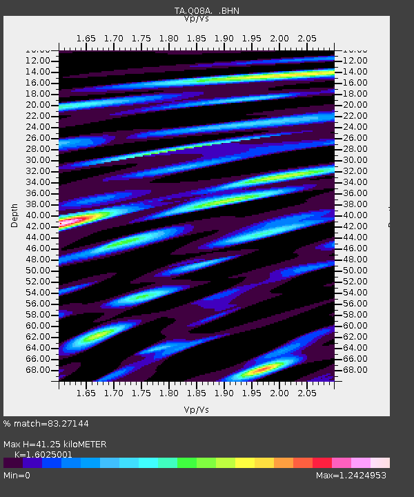
| Estimated Moho Depth: |
41.25 km |
| Estimated Crust Vp/Vs: |
1.60 |
| Assumed Crust Vp: |
6.276 km/s |
| Estimated Crust Vs: |
3.916 km/s |
| Estimated Crust Poisson's Ratio: |
0.18 |
|
| Radial Match: |
83.27144 % |
| Radial Bump: |
400 |
| Transverse Match: |
64.14389 % |
| Transverse Bump: |
400 |
| SOD ConfigId: |
2564 |
| Insert Time: |
2010-03-07 03:32:09.407 +0000 |
| GWidth: |
2.5 |
| Max Bumps: |
400 |
| Tol: |
0.001 |
|
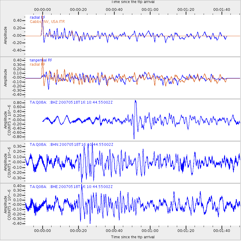
Signal To Noise
| Channel | StoN | STA | LTA |
| TA:Q08A: :BHN:20070518T16:10:44.55002Z | 1.401202 | 7.8194155E-8 | 5.5805057E-8 |
| TA:Q08A: :BHE:20070518T16:10:44.55002Z | 1.1399407 | 6.315258E-8 | 5.5399877E-8 |
| TA:Q08A: :BHZ:20070518T16:10:44.55002Z | 1.1296033 | 1.0762449E-7 | 9.527636E-8 |
| Arrivals |
| Ps | 4.1 SECOND |
| PpPs | 16 SECOND |
| PsPs/PpSs | 21 SECOND |


