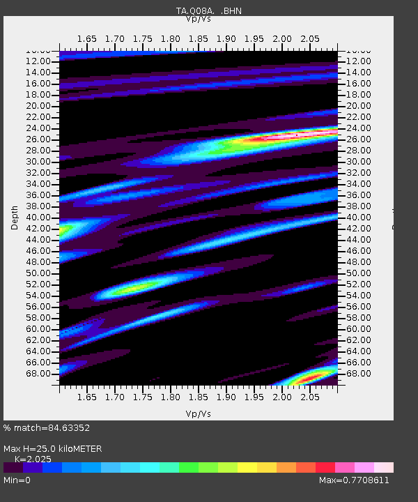
Q08A Gabbs, NV, USA - Earthquake Result Viewer

Earthquake location: Kermadec Islands, New Zealand
Earthquake latitude/longitude: -29.8/-178.0
Earthquake time(UTC): 2007/01/31 (031) 03:15:52 GMT
Earthquake Depth: 34 km
Earthquake Magnitude: 6.1 MB, 6.3 MS, 6.5 MW, 6.4 MW
Earthquake Catalog/Contributor: WHDF/NEIC
Network: TA USArray Transportable Network (new EarthScope stations)
Station: Q08A Gabbs, NV, USA
Lat/Lon: 38.86 N/117.93 W
Elevation: 1412 m
Distance: 88.3 deg
Az: 42.603 deg
Baz: 228.92 deg
Ray Param: 0.042655326
Estimated Moho Depth: 25.0 km
Estimated Crust Vp/Vs: 2.03
Assumed Crust Vp: 6.276 km/s
Estimated Crust Vs: 3.099 km/s
Estimated Crust Poisson's Ratio: 0.34
Radial Match: 84.63352 %
Radial Bump: 400
Transverse Match: 66.01572 %
Transverse Bump: 400
SOD ConfigId: 2564
Insert Time: 2010-03-07 03:32:14.166 +0000
GWidth: 2.5
Max Bumps: 400
Tol: 0.001

Signal To Noise

ChannelStoNSTALTA
TA:Q08A: :BHN:20070131T03:28:09.024009Z0.747112151.4656273E-71.9617232E-7
TA:Q08A: :BHE:20070131T03:28:09.024009Z1.1977852.7324157E-72.2812236E-7
TA:Q08A: :BHZ:20070131T03:28:09.024009Z4.61496351.1181711E-62.4229251E-7
Arrivals
Ps4.2 SECOND
PpPs12 SECOND
PsPs/PpSs16 SECOND