You are here: Home > Network List > AV - Alaska Volcano Observatory Stations List
> Station MAPS Pakushin Southeast, Makushin Volcano, Alaska > Earthquake Result Viewer
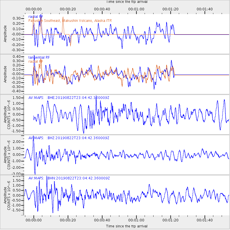
MAPS Pakushin Southeast, Makushin Volcano, Alaska - Earthquake Result Viewer
*The percent match for this event was below the threshold and hence no stack was calculated.
| Earthquake location: |
Santa Cruz Islands |
| Earthquake latitude/longitude: |
-12.6/167.0 |
| Earthquake time(UTC): |
2019/08/22 (234) 22:54:26 GMT |
| Earthquake Depth: |
213 km |
| Earthquake Magnitude: |
5.6 Mww |
| Earthquake Catalog/Contributor: |
NEIC PDE/us |
|
| Network: |
AV Alaska Volcano Observatory |
| Station: |
MAPS Pakushin Southeast, Makushin Volcano, Alaska |
| Lat/Lon: |
53.81 N/166.94 W |
| Elevation: |
333 m |
|
| Distance: |
69.7 deg |
| Az: |
16.095 deg |
| Baz: |
207.154 deg |
| Ray Param: |
$rayparam |
*The percent match for this event was below the threshold and hence was not used in the summary stack. |
|
| Radial Match: |
58.882557 % |
| Radial Bump: |
400 |
| Transverse Match: |
61.00558 % |
| Transverse Bump: |
400 |
| SOD ConfigId: |
19053131 |
| Insert Time: |
2019-09-05 22:59:29.004 +0000 |
| GWidth: |
2.5 |
| Max Bumps: |
400 |
| Tol: |
0.001 |
|
Signal To Noise
| Channel | StoN | STA | LTA |
| AV:MAPS: :BHZ:20190822T23:04:42.360009Z | 4.5024195 | 1.3473084E-6 | 2.9924095E-7 |
| AV:MAPS: :BHN:20190822T23:04:42.360009Z | 1.7039181 | 7.581998E-7 | 4.4497432E-7 |
| AV:MAPS: :BHE:20190822T23:04:42.360009Z | 1.8148255 | 8.958375E-7 | 4.936218E-7 |
| Arrivals |
| Ps | |
| PpPs | |
| PsPs/PpSs | |


