You are here: Home > Network List > TA - USArray Transportable Network (new EarthScope stations) Stations List
> Station Q08A Gabbs, NV, USA > Earthquake Result Viewer
Q08A Gabbs, NV, USA - Earthquake Result Viewer
| Earthquake location: |
Tonga Islands |
| Earthquake latitude/longitude: |
-21.3/-174.7 |
| Earthquake time(UTC): |
2006/11/30 (334) 11:33:17 GMT |
| Earthquake Depth: |
14 km |
| Earthquake Magnitude: |
5.7 MB, 6.1 MS, 6.0 MW, 6.0 MW |
| Earthquake Catalog/Contributor: |
WHDF/NEIC |
|
| Network: |
TA USArray Transportable Network (new EarthScope stations) |
| Station: |
Q08A Gabbs, NV, USA |
| Lat/Lon: |
38.86 N/117.93 W |
| Elevation: |
1412 m |
|
| Distance: |
80.0 deg |
| Az: |
41.525 deg |
| Baz: |
232.358 deg |
| Ray Param: |
0.048567723 |
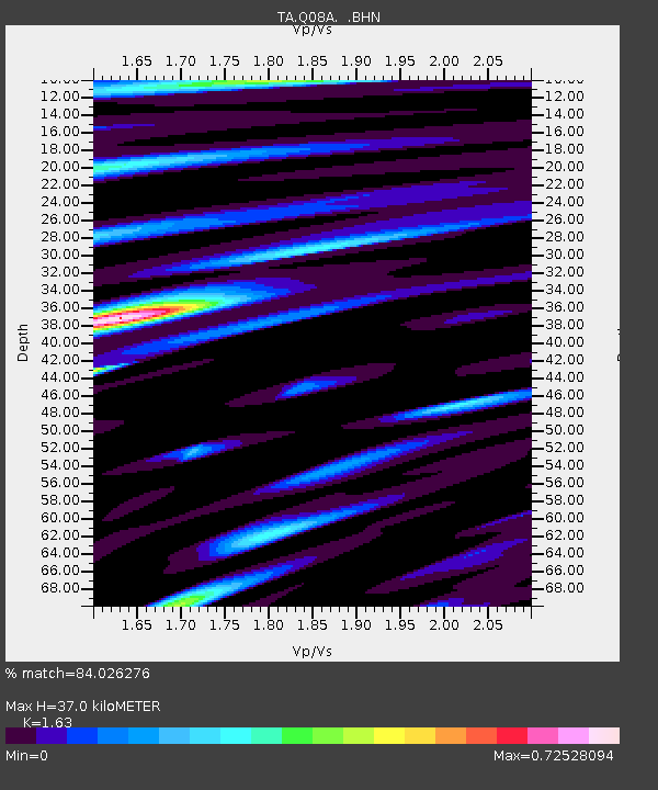
| Estimated Moho Depth: |
37.0 km |
| Estimated Crust Vp/Vs: |
1.63 |
| Assumed Crust Vp: |
6.276 km/s |
| Estimated Crust Vs: |
3.85 km/s |
| Estimated Crust Poisson's Ratio: |
0.20 |
|
| Radial Match: |
84.026276 % |
| Radial Bump: |
400 |
| Transverse Match: |
56.10868 % |
| Transverse Bump: |
400 |
| SOD ConfigId: |
2564 |
| Insert Time: |
2010-03-07 03:32:20.383 +0000 |
| GWidth: |
2.5 |
| Max Bumps: |
400 |
| Tol: |
0.001 |
|
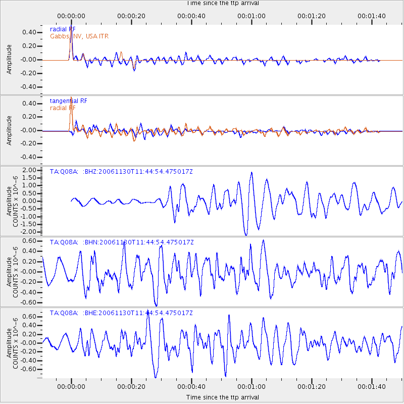
Signal To Noise
| Channel | StoN | STA | LTA |
| TA:Q08A: :BHN:20061130T11:44:54.475017Z | 1.333732 | 2.335326E-7 | 1.750971E-7 |
| TA:Q08A: :BHE:20061130T11:44:54.475017Z | 2.236193 | 1.6616991E-7 | 7.430929E-8 |
| TA:Q08A: :BHZ:20061130T11:44:54.475017Z | 4.310594 | 5.7050016E-7 | 1.3234839E-7 |
| Arrivals |
| Ps | 3.8 SECOND |
| PpPs | 15 SECOND |
| PsPs/PpSs | 19 SECOND |


