You are here: Home > Network List > TA - USArray Transportable Network (new EarthScope stations) Stations List
> Station Q08A Gabbs, NV, USA > Earthquake Result Viewer
Q08A Gabbs, NV, USA - Earthquake Result Viewer
| Earthquake location: |
Kuril Islands |
| Earthquake latitude/longitude: |
48.3/154.2 |
| Earthquake time(UTC): |
2006/11/12 (316) 21:27:42 GMT |
| Earthquake Depth: |
36 km |
| Earthquake Magnitude: |
6.1 MB, 5.4 MS, 5.9 MW, 5.9 MW |
| Earthquake Catalog/Contributor: |
WHDF/NEIC |
|
| Network: |
TA USArray Transportable Network (new EarthScope stations) |
| Station: |
Q08A Gabbs, NV, USA |
| Lat/Lon: |
38.86 N/117.93 W |
| Elevation: |
1412 m |
|
| Distance: |
61.0 deg |
| Az: |
63.128 deg |
| Baz: |
310.254 deg |
| Ray Param: |
0.061097134 |
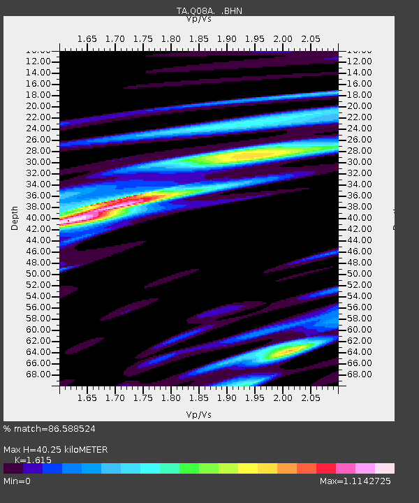
| Estimated Moho Depth: |
40.25 km |
| Estimated Crust Vp/Vs: |
1.62 |
| Assumed Crust Vp: |
6.276 km/s |
| Estimated Crust Vs: |
3.886 km/s |
| Estimated Crust Poisson's Ratio: |
0.19 |
|
| Radial Match: |
86.588524 % |
| Radial Bump: |
400 |
| Transverse Match: |
52.948055 % |
| Transverse Bump: |
400 |
| SOD ConfigId: |
2564 |
| Insert Time: |
2010-03-07 03:32:24.490 +0000 |
| GWidth: |
2.5 |
| Max Bumps: |
400 |
| Tol: |
0.001 |
|
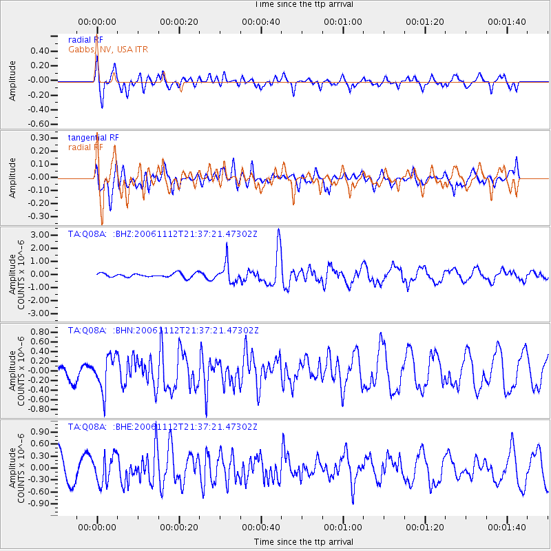
Signal To Noise
| Channel | StoN | STA | LTA |
| TA:Q08A: :BHN:20061112T21:37:21.47302Z | 1.7433102 | 3.6049596E-7 | 2.0678819E-7 |
| TA:Q08A: :BHE:20061112T21:37:21.47302Z | 1.1000769 | 3.499706E-7 | 3.1813283E-7 |
| TA:Q08A: :BHZ:20061112T21:37:21.47302Z | 4.8670797 | 7.5442244E-7 | 1.5500515E-7 |
| Arrivals |
| Ps | 4.1 SECOND |
| PpPs | 16 SECOND |
| PsPs/PpSs | 20 SECOND |


