You are here: Home > Network List > TA - USArray Transportable Network (new EarthScope stations) Stations List
> Station Q08A Gabbs, NV, USA > Earthquake Result Viewer
Q08A Gabbs, NV, USA - Earthquake Result Viewer
| Earthquake location: |
Tonga Islands |
| Earthquake latitude/longitude: |
-20.8/-174.2 |
| Earthquake time(UTC): |
2006/05/16 (136) 20:55:47 GMT |
| Earthquake Depth: |
15 km |
| Earthquake Magnitude: |
5.8 MB, 5.6 MS, 5.7 MW |
| Earthquake Catalog/Contributor: |
WHDF/NEIC |
|
| Network: |
TA USArray Transportable Network (new EarthScope stations) |
| Station: |
Q08A Gabbs, NV, USA |
| Lat/Lon: |
38.86 N/117.93 W |
| Elevation: |
1412 m |
|
| Distance: |
79.3 deg |
| Az: |
41.336 deg |
| Baz: |
232.349 deg |
| Ray Param: |
0.04906647 |
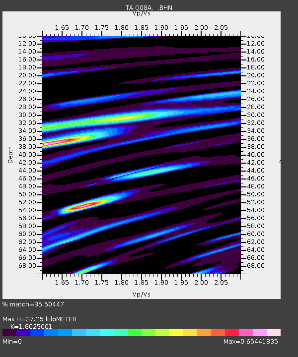
| Estimated Moho Depth: |
37.25 km |
| Estimated Crust Vp/Vs: |
1.60 |
| Assumed Crust Vp: |
6.276 km/s |
| Estimated Crust Vs: |
3.916 km/s |
| Estimated Crust Poisson's Ratio: |
0.18 |
|
| Radial Match: |
85.50447 % |
| Radial Bump: |
400 |
| Transverse Match: |
50.22789 % |
| Transverse Bump: |
400 |
| SOD ConfigId: |
2669 |
| Insert Time: |
2010-03-07 03:33:00.322 +0000 |
| GWidth: |
2.5 |
| Max Bumps: |
400 |
| Tol: |
0.001 |
|
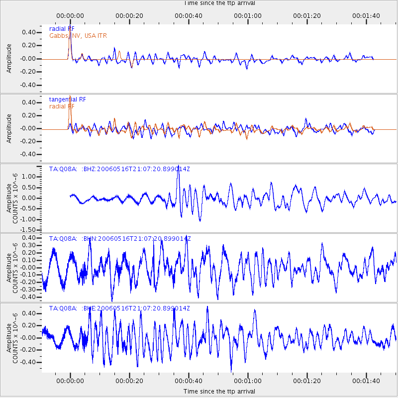
Signal To Noise
| Channel | StoN | STA | LTA |
| TA:Q08A: :BHN:20060516T21:07:20.899014Z | 0.8817219 | 1.2294024E-7 | 1.3943199E-7 |
| TA:Q08A: :BHE:20060516T21:07:20.899014Z | 0.87536156 | 1.2372743E-7 | 1.4134437E-7 |
| TA:Q08A: :BHZ:20060516T21:07:20.899014Z | 1.667327 | 1.84584E-7 | 1.1070653E-7 |
| Arrivals |
| Ps | 3.7 SECOND |
| PpPs | 15 SECOND |
| PsPs/PpSs | 19 SECOND |


