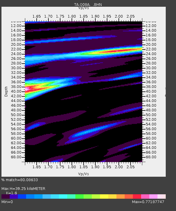
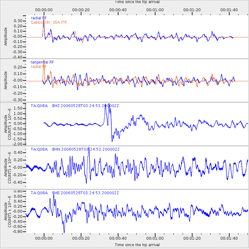
Q08A Gabbs, NV, USA - Earthquake Result Viewer

Earthquake location: New Britain Region, P.N.G.
Earthquake latitude/longitude: -5.7/151.1
Earthquake time(UTC): 2006/05/28 (148) 03:12:08 GMT
Earthquake Depth: 34 km
Earthquake Magnitude: 5.9 MB, 6.6 MS, 6.5 MW, 6.4 MW
Earthquake Catalog/Contributor: WHDF/NEIC
Network: TA USArray Transportable Network (new EarthScope stations)
Station: Q08A Gabbs, NV, USA
Lat/Lon: 38.86 N/117.93 W
Elevation: 1412 m
Distance: 94.3 deg
Az: 51.518 deg
Baz: 266.136 deg
Ray Param: 0.04106758
Estimated Moho Depth: 39.25 km
Estimated Crust Vp/Vs: 1.60
Assumed Crust Vp: 6.276 km/s
Estimated Crust Vs: 3.922 km/s
Estimated Crust Poisson's Ratio: 0.18
Radial Match: 80.08633 %
Radial Bump: 400
Transverse Match: 77.831604 %
Transverse Bump: 400
SOD ConfigId: 2669
Insert Time: 2010-03-07 03:33:01.983 +0000
GWidth: 2.5
Max Bumps: 400
Tol: 0.001

Signal To Noise

ChannelStoNSTALTA
TA:Q08A: :BHN:20060528T03:24:53.200002Z1.39747136.6620395E-84.7672103E-8
TA:Q08A: :BHE:20060528T03:24:53.200002Z1.98619381.8077596E-79.1016275E-8
TA:Q08A: :BHZ:20060528T03:24:53.200002Z8.3986697.01542E-78.353014E-8
Arrivals
Ps3.8 SECOND
PpPs16 SECOND
PsPs/PpSs20 SECOND