You are here: Home > Network List > TA - USArray Transportable Network (new EarthScope stations) Stations List
> Station B18K Kokolik River, AK, USA > Earthquake Result Viewer
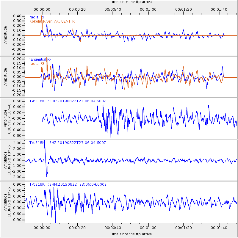
B18K Kokolik River, AK, USA - Earthquake Result Viewer
*The percent match for this event was below the threshold and hence no stack was calculated.
| Earthquake location: |
Santa Cruz Islands |
| Earthquake latitude/longitude: |
-12.6/167.0 |
| Earthquake time(UTC): |
2019/08/22 (234) 22:54:26 GMT |
| Earthquake Depth: |
213 km |
| Earthquake Magnitude: |
5.6 Mww |
| Earthquake Catalog/Contributor: |
NEIC PDE/us |
|
| Network: |
TA USArray Transportable Network (new EarthScope stations) |
| Station: |
B18K Kokolik River, AK, USA |
| Lat/Lon: |
69.36 N/161.80 W |
| Elevation: |
222 m |
|
| Distance: |
84.6 deg |
| Az: |
10.614 deg |
| Baz: |
210.483 deg |
| Ray Param: |
$rayparam |
*The percent match for this event was below the threshold and hence was not used in the summary stack. |
|
| Radial Match: |
66.60333 % |
| Radial Bump: |
400 |
| Transverse Match: |
66.9242 % |
| Transverse Bump: |
400 |
| SOD ConfigId: |
19053131 |
| Insert Time: |
2019-09-05 23:03:53.186 +0000 |
| GWidth: |
2.5 |
| Max Bumps: |
400 |
| Tol: |
0.001 |
|
Signal To Noise
| Channel | StoN | STA | LTA |
| TA:B18K: :BHZ:20190822T23:06:04.600Z | 6.8122697 | 1.3193935E-6 | 1.93679E-7 |
| TA:B18K: :BHN:20190822T23:06:04.600Z | 2.8511724 | 3.5668288E-7 | 1.2510043E-7 |
| TA:B18K: :BHE:20190822T23:06:04.600Z | 1.5834345 | 1.7204472E-7 | 1.08652884E-7 |
| Arrivals |
| Ps | |
| PpPs | |
| PsPs/PpSs | |


