You are here: Home > Network List > TA - USArray Transportable Network (new EarthScope stations) Stations List
> Station E22K Anaktuvuk Pass, AK, USA > Earthquake Result Viewer
E22K Anaktuvuk Pass, AK, USA - Earthquake Result Viewer
| Earthquake location: |
Santa Cruz Islands |
| Earthquake latitude/longitude: |
-12.6/167.0 |
| Earthquake time(UTC): |
2019/08/22 (234) 22:54:26 GMT |
| Earthquake Depth: |
213 km |
| Earthquake Magnitude: |
5.6 Mww |
| Earthquake Catalog/Contributor: |
NEIC PDE/us |
|
| Network: |
TA USArray Transportable Network (new EarthScope stations) |
| Station: |
E22K Anaktuvuk Pass, AK, USA |
| Lat/Lon: |
68.13 N/151.81 W |
| Elevation: |
772 m |
|
| Distance: |
85.7 deg |
| Az: |
14.308 deg |
| Baz: |
220.099 deg |
| Ray Param: |
0.044066556 |
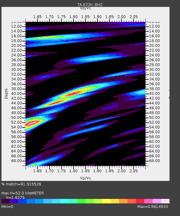
| Estimated Moho Depth: |
52.0 km |
| Estimated Crust Vp/Vs: |
1.63 |
| Assumed Crust Vp: |
6.221 km/s |
| Estimated Crust Vs: |
3.822 km/s |
| Estimated Crust Poisson's Ratio: |
0.20 |
|
| Radial Match: |
91.515526 % |
| Radial Bump: |
400 |
| Transverse Match: |
93.28656 % |
| Transverse Bump: |
400 |
| SOD ConfigId: |
19053131 |
| Insert Time: |
2019-09-05 23:04:07.029 +0000 |
| GWidth: |
2.5 |
| Max Bumps: |
400 |
| Tol: |
0.001 |
|

Signal To Noise
| Channel | StoN | STA | LTA |
| TA:E22K: :BHZ:20190822T23:06:10.024987Z | 30.547039 | 1.5665835E-6 | 5.1284296E-8 |
| TA:E22K: :BHN:20190822T23:06:10.024987Z | 13.213999 | 5.475512E-7 | 4.1437204E-8 |
| TA:E22K: :BHE:20190822T23:06:10.024987Z | 3.806449 | 2.342784E-7 | 6.154776E-8 |
| Arrivals |
| Ps | 5.4 SECOND |
| PpPs | 21 SECOND |
| PsPs/PpSs | 27 SECOND |


