You are here: Home > Network List > TA - USArray Transportable Network (new EarthScope stations) Stations List
> Station G22K Bettles, AK, USA > Earthquake Result Viewer
G22K Bettles, AK, USA - Earthquake Result Viewer
| Earthquake location: |
Santa Cruz Islands |
| Earthquake latitude/longitude: |
-12.6/167.0 |
| Earthquake time(UTC): |
2019/08/22 (234) 22:54:26 GMT |
| Earthquake Depth: |
213 km |
| Earthquake Magnitude: |
5.6 Mww |
| Earthquake Catalog/Contributor: |
NEIC PDE/us |
|
| Network: |
TA USArray Transportable Network (new EarthScope stations) |
| Station: |
G22K Bettles, AK, USA |
| Lat/Lon: |
66.92 N/151.51 W |
| Elevation: |
205 m |
|
| Distance: |
84.9 deg |
| Az: |
15.189 deg |
| Baz: |
220.454 deg |
| Ray Param: |
0.04466617 |
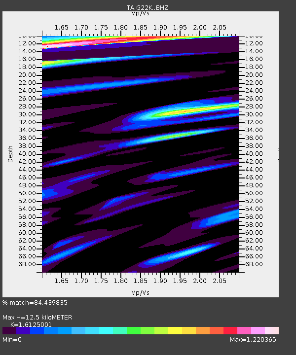
| Estimated Moho Depth: |
12.5 km |
| Estimated Crust Vp/Vs: |
1.61 |
| Assumed Crust Vp: |
6.577 km/s |
| Estimated Crust Vs: |
4.079 km/s |
| Estimated Crust Poisson's Ratio: |
0.19 |
|
| Radial Match: |
84.439835 % |
| Radial Bump: |
400 |
| Transverse Match: |
84.6086 % |
| Transverse Bump: |
400 |
| SOD ConfigId: |
19053131 |
| Insert Time: |
2019-09-05 23:04:25.152 +0000 |
| GWidth: |
2.5 |
| Max Bumps: |
400 |
| Tol: |
0.001 |
|

Signal To Noise
| Channel | StoN | STA | LTA |
| TA:G22K: :BHZ:20190822T23:06:05.824975Z | 21.947407 | 1.583883E-6 | 7.2167204E-8 |
| TA:G22K: :BHN:20190822T23:06:05.824975Z | 5.8167124 | 4.285395E-7 | 7.367383E-8 |
| TA:G22K: :BHE:20190822T23:06:05.824975Z | 3.98993 | 2.5685858E-7 | 6.437672E-8 |
| Arrivals |
| Ps | 1.2 SECOND |
| PpPs | 4.8 SECOND |
| PsPs/PpSs | 6.0 SECOND |


