You are here: Home > Network List > TA - USArray Transportable Network (new EarthScope stations) Stations List
> Station J19K Poorman, AK, USA > Earthquake Result Viewer
J19K Poorman, AK, USA - Earthquake Result Viewer
| Earthquake location: |
Santa Cruz Islands |
| Earthquake latitude/longitude: |
-12.6/167.0 |
| Earthquake time(UTC): |
2019/08/22 (234) 22:54:26 GMT |
| Earthquake Depth: |
213 km |
| Earthquake Magnitude: |
5.6 Mww |
| Earthquake Catalog/Contributor: |
NEIC PDE/us |
|
| Network: |
TA USArray Transportable Network (new EarthScope stations) |
| Station: |
J19K Poorman, AK, USA |
| Lat/Lon: |
63.99 N/155.62 W |
| Elevation: |
389 m |
|
| Distance: |
81.5 deg |
| Az: |
15.683 deg |
| Baz: |
216.773 deg |
| Ray Param: |
0.047017246 |
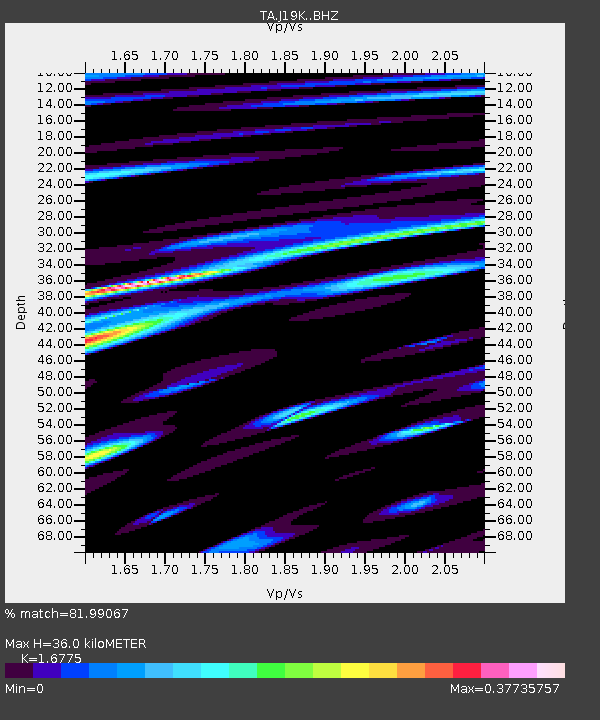
| Estimated Moho Depth: |
36.0 km |
| Estimated Crust Vp/Vs: |
1.68 |
| Assumed Crust Vp: |
6.438 km/s |
| Estimated Crust Vs: |
3.838 km/s |
| Estimated Crust Poisson's Ratio: |
0.22 |
|
| Radial Match: |
81.99067 % |
| Radial Bump: |
400 |
| Transverse Match: |
73.44554 % |
| Transverse Bump: |
400 |
| SOD ConfigId: |
19053131 |
| Insert Time: |
2019-09-05 23:04:46.698 +0000 |
| GWidth: |
2.5 |
| Max Bumps: |
400 |
| Tol: |
0.001 |
|

Signal To Noise
| Channel | StoN | STA | LTA |
| TA:J19K: :BHZ:20190822T23:05:48.675012Z | 9.987894 | 9.185752E-7 | 9.1968865E-8 |
| TA:J19K: :BHN:20190822T23:05:48.675012Z | 4.1923676 | 2.7581987E-7 | 6.579096E-8 |
| TA:J19K: :BHE:20190822T23:05:48.675012Z | 3.3302734 | 2.2590181E-7 | 6.7832815E-8 |
| Arrivals |
| Ps | 3.9 SECOND |
| PpPs | 15 SECOND |
| PsPs/PpSs | 18 SECOND |


